
Unusual Pacific Storms Like Hurricane Hilary Could be a Warning for the Future
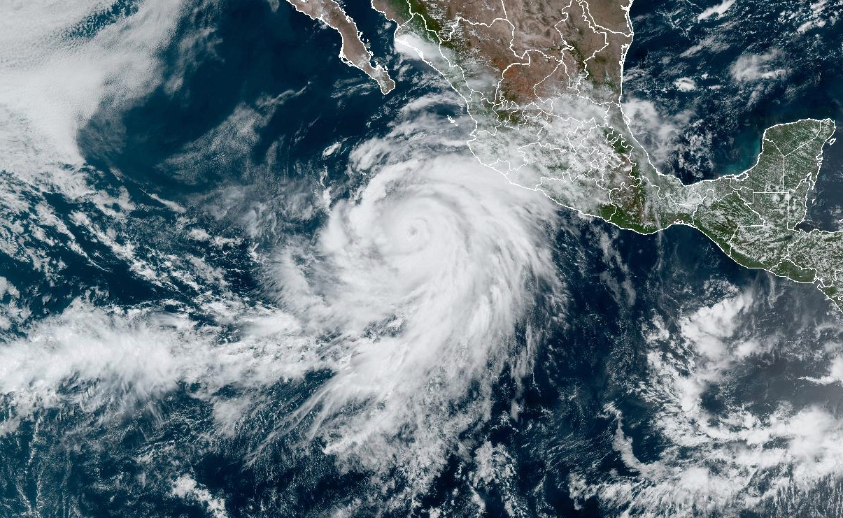
During this summer of climate extremes, it’s hard not to wonder what’s next. For millions of people in the Southwestern United States and Mexico, the answer might be unprecedented summer rains and flooding from Hurricane Hilary as the Category 4 storm barrels up Mexico’s western coast toward Southern California.
But a lack of research and data about the rare tropical cyclones in the region will leave many continuing to wonder about how often they’ll face such storms as the Eastern Pacific warms.
National Weather Service forecasters on Friday issued the first-ever tropical storm watch for Southern California, and said the “serious and unusual situation” includes the threat of a tropical cyclone moving up into Southern California on Sunday and Monday, with widespread flooding possible and the potential for tropical storm-force wind gusts above 50 mph. National Hurricane Center forecasters anticipated that Hilary’s winds could be at 100 mph as it approaches the Southern California coast.
“I’m watching very carefully to see what track it’ll take, because the information we have so far is, there will be impacts,” said Kim Wood, an atmospheric scientist at the University of Arizona who studies tropical cyclones in the East Pacific. “It’s still uncertain if the impacts will be from a direct hit or if the storm center will stay offshore.” Either way, she added, the system will bring wind and a big surge of moisture to the deserts of southern California, Nevada and Arizona.
“Hilary is already really big, and storms don’t tend to shrink quickly once they get to that size,” she said. “If it undergoes something called an eyewall replacement cycle, it might get weaker, but it’ll get bigger. And the bigger it gets, the more likely it is to maintain its structure.” That means even when it moves over cooler water near California, the storm is still likely to reach farther inland, she added. The storm, however, will weaken to below hurricane strength before making landfall, likely as a tropical storm, she said.
East Pacific hurricanes generally form off the coast of Mexico and often head west, away from land, losing strength as they curve northward over cooler water. But depending on seasonal weather patterns, some curve back toward the east, making often-damaging landfalls along the west coast of Mexico.
But having a major hurricane barreling due north toward California is exceedingly rare, and the tropical storm watch issued for Southern California, is a “historic first for CA,” climate scientist Daniel Swain posted on social media, adding that rainfall amounts in the deserts of southeastern California could be equally historic, with one to two years worth of rain falling in the next few days. Rainfall of 3 to 6 inches, and up to 10 inches in spots, is expected across portions of southern California and southern Nevada, “which would lead to significant and rare impacts,” according to the National Weather Service.

Hurricane Hilary’s winds strengthened from 40 mph to more than 100 mph in about 12 hours on Thursday, more than double the rate that defines rapid intensification. That development matches a global trend of hurricanes intensifying more quickly since 1991, which is probably caused by warming oceans, hurricane researchers wrote in a 2020 study.
Another peer-reviewed journal article in 2021 showed that major hurricanes made up an increasing percentage of the overall total number of tropical cyclones since 1979. A 2022 study showed how warming has increased extreme rainfall from hurricanes, and there is also scientific evidence suggesting that the stronger storms fueled by global warming are maintaining their intensity longer as they move inland.
Earlier this month, Hurricane Dora became the longest-lived Category 4 storm on record in the Pacific Ocean, maintaining its strength over thousands of miles and helping to fuel strong winds that drove the deadly and destructive wildfires on Maui. Many of the Eastern Pacific’s strongest storms on record have occurred in the past couple of decades, including Hurricane Patricia in 2015, which had the highest wind speeds of any storm on record.
Eastern Pacific Hurricane Data Is Sparse
Despite some of the clear global trends, the Eastern Pacific remains an understudied region, probably because many of the hurricanes move away from land. The National Hurricane Center doesn’t issue seasonal projections for the Eastern Pacific, like the closely watched Atlantic hurricane season forecast. And the long-term data record for hurricanes in the region was disrupted by a 1988 change in jurisdiction, as record-keeping switched from the Eastern Pacific Hurricane Center in Redwood City, Calif., to the National Hurricane Center in Miami. Inconsistency in the record makes it harder to detect any global warming fingerprints on hurricanes in the region, Wood said.
“One of our challenges in the eastern north Pacific is the quality of the data record,” she said. “The transition of information from the old center to new center wasn’t smooth, and some information was lost. So a lot of the analyses that have been done have been looking mostly at the most recent 35 years. That’s not a lot of time to say, ‘Hey, this is what the pattern used to be, and this is how we’re seeing it change into the future.’”
Wood said a lack of paleoclimate evidence also makes it harder to assess the effects of global warming on hurricane activity in the Eastern Pacific. In the Atlantic Basin, climate researchers can look at old wave-cut terraces on the shore, and measure the chemical composition of cave formations to explore hurricane activity in past geological eras. There are very few geological formations suitable for such measurements in areas affected by Eastern Pacific hurricanes.
“The rugged terrain along the coast of Mexico just isn’t conducive to the same type of studies, partly because it’s just hard to get there,” she said. “The topography and the geology may not produce the same kind of information that you’d get in other parts of the world.”
Scientists can look back at data showing the environment around past storms, including factors like sea surface temperatures and upper level winds that steer hurricanes, to get a general sense of how those may have changed over time. But for now, the lack of hurricane-specific data and research in the region makes it much harder to say whether global warming will increase the chance of more tropical systems reaching densely populated Southern California.
One thing that may increase the risk is the steady rise of sea surface temperatures. For now, the ocean off the coast of Southern California is often below 79 degrees Fahrenheit, which is the minimum needed to sustain a tropical system. But, as in other areas, the ocean in the region is heating up quickly, and if it starts to stay above that temperature, it could drive storms longer on a northward track.
“If we look at the last 60 years or so, the trend is definitely positive,” Wood said of the increasing water temperatures in the region. “We’re looking at a half-degree Fahrenheit every 10 years. We still have that quick change in sea surface temperatures in that area, but sea surface temperatures are going up, and there’s kind of an impressive blob of warming right off the coast of Baja California.”
Keep Environmental Journalism Alive
ICN provides award-winning climate coverage free of charge and advertising. We rely on donations from readers like you to keep going.
In fact, warmer oceans are almost certain to fuel stronger hurricanes in parts of the Pacific, including around Hawai’i, said Hiroyuki Murakama, a climate researcher at the University Corporation for Atmospheric Research’s Geophysical Fluid Dynamics Laboratory at Princeton University.
In a 2013 study, Murakami and other researchers projected that tropical storm frequency in the central Pacific around Hawai’i would double with a temperature increase of 3.6 degrees Fahrenheit (2 degrees Celsius). Recent extreme hurricane seasons in the Pacific are in line with those projections, he said. In other research he published in 2017, Murakama found links between global warming and extreme Pacific hurricane activity in 2015.
But he has also documented an overall decrease in tropical storms in the Eastern Pacific in the last 40 years, even as climate models project more activity.
“There’s a big difference between the climate models and observations,” he said, adding that those larger uncertainties need to be resolved before making projections about whether the hurricane threat will grow in Southern California.
Even if there’s not enough data to make accurate projections about how global warming will affect the path of future Eastern Pacific hurricanes, there are other alarming trends, Wood said.
“What we’re noticing is that when storms form, they tend to intensify, often very quickly and they can get very strong,” she said. Sometimes that happens right at the coast. And that’s terrifying, because it worsens impacts and it also decreases the time to prepare for those impacts.”
    <div class="post-author-bio">


            <div class="image-holder">

                <img width="300" height="300" src="https://insideclimatenews.org/wp-content/uploads/2020/11/gOmMa-dc_400x400-300x300.jpg" class="attachment-thumbnail-medium-square size-thumbnail-medium-square" alt decoding="async" srcset="https://insideclimatenews.org/wp-content/uploads/2020/11/gOmMa-dc_400x400-300x300.jpg 300w, https://insideclimatenews.org/wp-content/uploads/2020/11/gOmMa-dc_400x400-150x150.jpg 150w, https://insideclimatenews.org/wp-content/uploads/2020/11/gOmMa-dc_400x400-64x64.jpg 64w, https://insideclimatenews.org/wp-content/uploads/2020/11/gOmMa-dc_400x400.jpg 320w" sizes="(max-width: 300px) 100vw, 300px">
            </div> <!-- /.image-holder -->


        <div class="content">

            <h3 class="author-name">

                <a href="https://insideclimatenews.org/profile/bob-berwyn/">
                    Bob Berwyn                  </a>

            </h3>


                <h4 class="profile-subtitle">Reporter, Austria</h4>


                Bob Berwyn an Austria-based reporter who has covered climate science and international climate policy for more than a decade. Previously, he reported on the environment, endangered species and public lands for several Colorado newspapers, and also worked as editor and assistant editor at community newspapers in the Colorado Rockies.


        </div> <!-- /.bio -->

    </div> <!-- /.post-author-bio -->


