
New York City Begins Its Climate Change Reckoning on the Lower East Side, the Hard Way
Next to the Brooklyn Bridge, on an unassuming red brick building, a preserved chalk line serves as a permanent reminder of the 14-foot waves from Hurricane Sandy that inundated Lower Manhattan in October 2012, closed Wall Street, blacked out power to a quarter of a million city residents and killed 44 New Yorkers.
Less than a year later, in August 2013, the Obama administration’s Department of Housing and Urban Development picked a well-known Danish architecture firm, the Bjarke Ingels Group—BIG for short—in a competition called Rebuild by Design. Bjarke Ingels was selected for its plan to protect a vast expanse of Manhattan from future flooding “as we prepare communities across the country for the impacts of a changing climate,” HUD Secretary Shaun Donovan said at the time.
The following June, the department sent New York a $335 million check to build a 2.4-mile span of berms, floodwalls and water gates along the city’s Lower East Side as the first phase in the firm’s “BIG U” vision for a 10-mile, U-shaped water defense that would run from 57th Street on the West Side to the tip of Lower Manhattan, and then up to 42nd Street on the East Side.

The first phase, now called the East Side Coastal Resiliency Project, was described by city and federal officials in 2014 as a “nature as buffer” approach that would allow the beloved East River Park, built by Robert Moses in the 1930s, to flood during climate-amplified extreme weather events. Officials said that phase would cost $770 million and be finished in as little as four years.
None of that turned out to be true.
In what began as a design effort focused on community involvement, the administration of former Mayor Bill de Blasio scrapped the permeable design in the face of engineering complexities in 2018 without telling community groups as the price tag soared to $1.45 billion. Anger among people in the community led to various lawsuits and a court stay, now lifted, that have helped delay completion until 2026.
Which means the Lower East Side, which was among the neighborhoods hardest hit by Sandy, remains as vulnerable now as it was when the storm blew ashore more than a decade ago. “It’s kind of all or nothing when you’re building a wall,” said Joseph Lione, associate commissioner for coastal resiliency construction at the city’s Department of Design and Construction.
As such, the East Side Coastal Resiliency Project proceeds as an object lesson in the sheer complexity faced by New York City in adapting to the worsening climate crisis. Four other similarly complicated projects will create, if not the original BIG U, then a BIG J, that would stretch from the East Side at 25th Street, past the Brooklyn Bridge, through the South Street Seaport and financial districts, around Battery Park all the way up Chambers Street on the West Side, at a price tag now approaching $3 billion. And the Army Corps of Engineers is developing further plans to develop another 27 miles of coastal barriers to finish the protection of Lower Manhattan, in addition to the shorelines of East Harlem, Brooklyn, Queens and Jersey City. Price tag: another $61.5 billion.
A spokesperson for New York Mayor Eric Adams’ Office of Climate and Environmental Justice called the East Side Coastal Resiliency Project alone “one of the most technically complex resiliency projects anywhere in the world,” one that “integrates flood protections seamlessly into New York City’s urban fabric while renewing and strengthening beloved public spaces like East River Park.”
Robert Freudenberg, a vice president at the Regional Plan Association, a leading nonprofit planning organization for the New York metropolitan area, said flatly that it was a “mistake” for the de Blasio administration to redesign the project without involving the community. But the revamped project is now five years on and making real progress, with another three to go.
“I think it was a learning lesson for New York City,” he said. “It’s really hard to adapt to climate change because we’ve never adapted to climate change before.”
A Reckoning With Climate Change
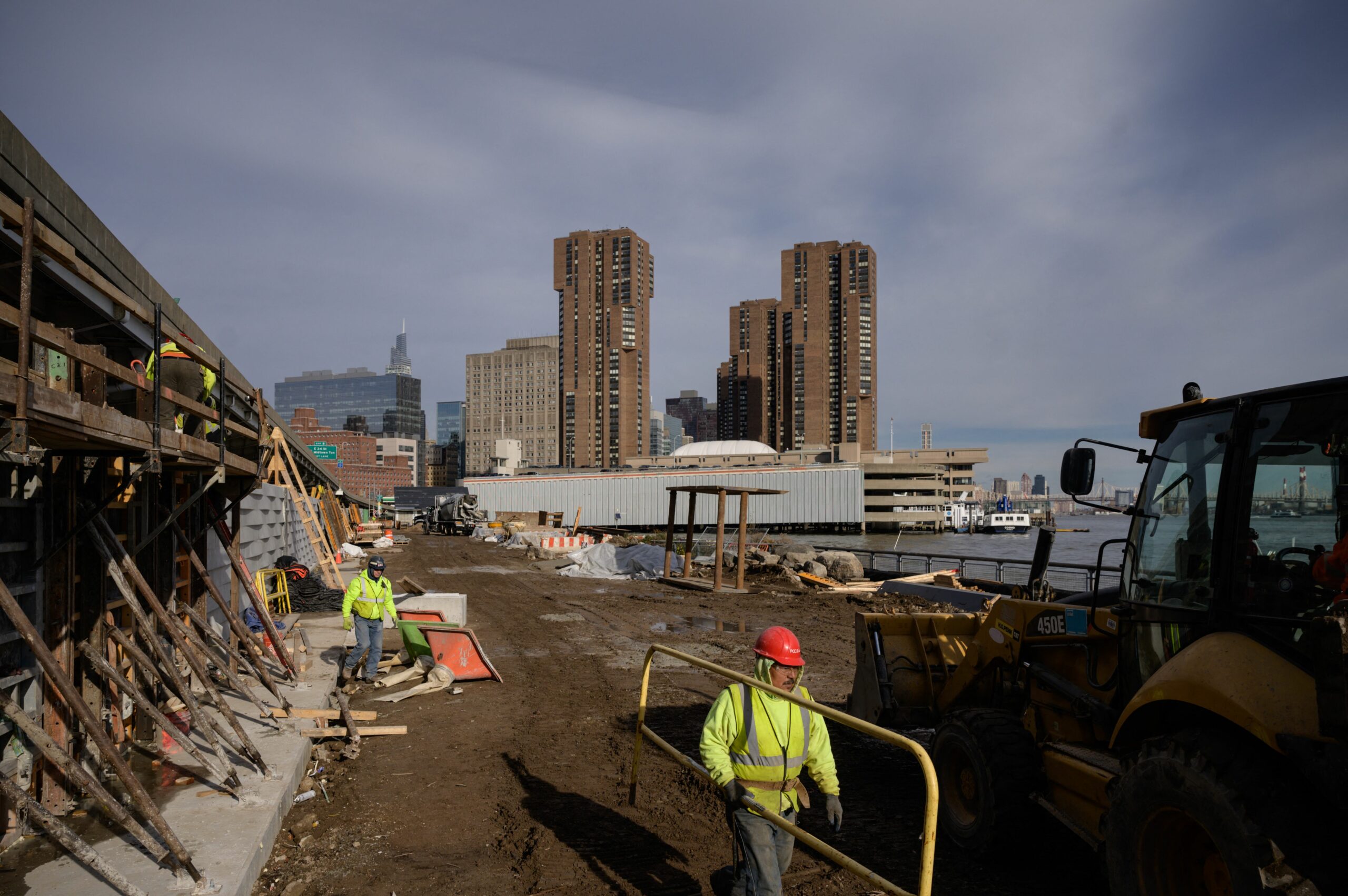
In all its redesigned complexity, the East Side Coastal Resiliency Project will eventually span 2.4 miles, include 18 movable floodgates, and protect 110,000 New Yorkers, including more than 28,000 low-income public-housing residents, from future storm surge damage. It runs from Montgomery Street, between the Manhattan and Williamsburg bridges, north to East 25th Street.
It incorporates the first climate-inspired reimagining of the East River Park, which runs between the FDR Drive and the East River for about half the length of the project. Completed by Moses in 1939, the park provided 50 acres of green space next to the highway and the city’s first federally subsidized public housing.
Completing it and the rest of the BIG U, will mark the start of New York City’s nuts-and-bolts reckoning with the systemic crisis of climate change. As sea levels rise, critical infrastructure in the lower precincts of Manhattan will be at risk due to rising sea level and increasing storm surge.
Amy Chester, managing director of Rebuild by Design, the planning organization that ran the original design competition, said community involvement was strong during the initial design phase of the East Side Coastal Resiliency Project, until de Blasio’s office dismantled the initiative’s task force in 2018. The task force, comprising several local community boards and other stakeholders, had been contributing to the design process over the previous four and a half years.
“Obviously it was a huge mistake that the mayor’s office decided not to bring this group back together to have a conversation about what they were finding,” Chester said. “Even the mayor’s office has admitted that they were wrong.”
The original design called for East River Park to be transformed into a wetlands area that would rise to meet a floodwall to be built along the FDR Drive. But complexity soon overwhelmed the original design. For starters, the New York City Department of Parks and Recreation is not equipped to maintain a park designed to flood.
Then there were concerns about power lines that run from the Con Edison power station near 14th Street along the edge of East River Park to electrify Lower Manhattan. Transportation planners worried about disrupting traffic on the FDR Drive.
What came out of the city’s closed-door redesign in 2018 was moving a 10-foot floodwall that runs the 1.2-mile length of the park closer to the waterfront and bracing it with 10 feet of landfill, with a new park to be built on top. The price tag doubled to $1.45 billion.
The new design improved recreation amenities in the park and protected both Con Edison’s power station and the Manhattan Pump Station, a wastewater treatment facility that had been upgraded in 2011 for $236 million.
If all that wasn’t complicated enough, the new design includes work to improve drainage infrastructure on the Lower East Side to increase capacity during storms. The Waterfront Alliance, a planning coalition, endorsed the project last fall for many features of its design, including the use of modeling that assumes storm surges and major precipitation events will be happening at the same time.
Joseph Sutkowi, chief waterfront design officer for the Waterfront Alliance, said that this assumption was unusual and would ensure greater protection upon the project’s completion. Storm surges create pressure on the drainage system, which would hamper the effectiveness of the stormwater infrastructure during a major precipitation event.
“It’s really important to move quickly on these resilience projects because of the risk that we could have a storm in the interim,” Sutkowi said. “Right now, that neighborhood is unprotected, and a Sandy would have almost the same effect today as it had 10 years ago.”
Chester of Rebuild by Design said she believed that the new design was the best feasible plan. Elevating the park will make it easier for the Department of Parks and Recreation to maintain. Certain amenities, such as the soccer field, would have been destroyed by water pooling in the park, requiring frequent replacement, and a phased construction plan will ensure that “a little more than half the park is available at all times,” said Carlina Rivera, a City Council member who represents several Lower East Side neighborhoods.
With a new park 10 feet above the original, planners say the amenities and ultimately the inland infrastructure will be protected from the three to six feet of sea level rise estimated to be possible in New York City over the next few decades.
Keep Environmental Journalism Alive
ICN provides award-winning climate coverage free of charge and advertising. We rely on donations from readers like you to keep going.
The city also invested in additional substructure at the base of the project that would allow the seawall to be raised higher if needed, according to Chester. This means that if the sea level were to rise faster than predicted, the seawall could be extended.
“I feel pretty strongly that if they would have brought everyone back together and said, ‘Hey, these are the things we’re running into so let’s make this decision together,’ the group would have ended up with the same decision,” she said.
But the damage was done. The city’s secrecy led to court battles and has left pockets of simmering animosity throughout the community.
Shattered Trust, Divided Community
Tommy Loeb, who has lived across from East River Park for 45 years, Is still enraged that his community wasn’t consulted about changes to the project.
A member of the East River Park Action group, Loeb said he was disappointed with how the de Blasio administration handled the changes made to the design. “The city lied to us,” he added. “They secretly developed this new plan and without telling anyone, including local elected officials, just announced it without any outside expert review or opportunity to look at alternatives.”
After the new plan was announced, the action group sought to uncover documents explaining how the new design came to be. They submitted Freedom of Information requests to the city’s Department of Design and Construction to retrieve a value engineering study that was used to justify changing 70 percent of the earlier plan. When the report was released in 2021, it was heavily redacted.
“What we want is a good plan,” Loeb said. He contends that the new plan is not the only design that would have been feasible. “If experts came to us and said, ‘This is the only thing we can do,’ we would accept that.”
Many public housing tenants and others in the community have come to support the new design. Still, some resentment lingers among resident groups, including some that support the project, in addition to some like Loeb’s that are still expressing grievances.
Even the trees in the park became a source of tension, dividing community groups and underscoring how climate change is requiring a new approach to urban design, even among arborists.
Once the new design had been unveiled, the East River Park Action group complained that it required cutting down approximately 1,000 trees. But those trees, London planes and cherry, chosen by Moses for their aesthetic and perceived hardiness, had been badly damaged by Hurricane Sandy.
The London planes were not well adapted to life along the coast. In 2012, about 48,000 street trees were affected by flooding during the storm. Nearly 11,000 trees died in its immediate aftermath. Over the next few years, the city lost an additional 11,000 trees to the long-term effects of saltwater inundation.
Saltwater intrusion occurs when saline water moves into freshwater aquifers, and it can be worsened by extreme weather events like hurricane storm surges. The city is now planning for the inevitability that seawater will continue to flow further inland beneath fresh groundwater.
Ben Osborne, the assistant commissioner for forestry and horticulture at the Parks Department, said that Sandy was a wake-up call that London planes cannot tolerate saltwater.
“We’ve spent more than 10 years since Sandy continuing to refine our coastal species planting internal guidelines,” he added. The list now includes about three or four dozen trees recommended for planting along the coastal areas of the city where saltwater inundation poses a threat.
Ian Michaels, spokesman for the city’s Department of Design and Construction, said that plans for the new park include around 2,000 trees, representing about 50 different species chosen based on guidelines for coastal planting. Plants other than trees will also be added in accordance with their resilience to saltwater spray.
Rivera, the City Council member, said that in addition to the trees planned for the park, more trees are to be planted inland throughout local neighborhoods to combat the urban heat island effect.
Finishing the ‘BIG J’
On the 10th anniversary of Hurricane Sandy last October, not far from the red brick building with the preserved chalk line next to the Brooklyn Bridge, Adams declared that Sandy “wasn’t just a storm—it was a warning.”
The mayor and other officials had come to the Two Bridges neighborhood in Lower Manhattan to break ground on the city’s Brooklyn-Bridge Montgomery Coastal Resiliency Project, which will pick up where the East Side Coastal Resiliency Project ends below the southern edge of East River Park and extend a system of floodwalls, flip-up barriers and expanded sewers to the Brooklyn Bridge.
The flip-up gates are distinct from the 18 gates that will protect the Lower East Side. They are designed to lie flat on the ground and turn upright for over a half-mile when a storm surge is expected. “They go up in about 30-foot sections,” said Lione of the Department of Design and Construction. “It’s a very unique structure.”
Additionally, the New York City Economic Development Corporation and the Mayor’s Office of Climate Resiliency have released a master plan to protect the financial and South Street Seaport districts from storm surges. The plan involves burying floodwalls in the landscape, building 15- to 18-foot elevated public open spaces and installing a new stormwater pump station. The waterfront to be protected includes a mile-long stretch from the Brooklyn Bridge to the Battery.
Another elevated waterfront is expected to be built around the Battery, a 25-acre park and wharf that includes an urban farm, gardens and a SeaGlass Carousel. This interlocking project is being planned by the Economic Development Corporation, the Parks and Recreation Department, and the Mayor’s Office of Climate and Environmental Justice. The new wharf would be elevated by five feet and feature an enhanced drainage system and permeable pavements.
On the southwestern tip of Manhattan, the Battery Park City Authority, a state-run public-benefit corporation, is also working on a major coastal resiliency project. The plan, which would involve razing Robert F. Wagner Jr. Park and rebuilding it about 10 feet higher, is currently undergoing review by the Waterfront Alliance. Sutkowi said that a preliminary review had been completed and that the plan would be fully evaluated once all of the construction documents are finalized.
These projects, stretching from the East Side at 25th Street to the West Side at Chambers Street, will eventually come together to protect Lower Manhattan via a J shaped series of floodwalls and gates.
The mayor has appealed for about $8.5 billion in federal “pre-disaster mitigation grant funding” for climate resiliency. “New York City’s infrastructure projects are more complex, novel and unparalleled compared to any other American city, but many remain in various stages of completion,” Adams said.
An Alternative, 3B, May Hinge on Feedback
He said the $8.5 billion would be a down payment on what the U.S. Army Corps of Engineers now calls its 3B alternative.
The Army Corps began studying New York City’s coastal storm surge preparedness in 2017. Its original project was halted in February 2020 after President Donald Trump mocked the largest possible alternative, a $119 billion plan to erect giant floodgates across New York Harbor that he falsely claimed would cost $200 billion.
The corps’ 3B alternative, on which it is accepting public comments on through March 31, has an estimated budget of $61.5 billion. As a preliminary concept and a recommendation to be proposed to Congress, the proposal calls for a combination of deployable flood barriers, floodwalls, seawalls and elevated promenades in Manhattan extending the BIG J all the way up to West 34th Street. That is about 23 blocks short of the original BIG U concept, which had proposed that the new infrastructure start at West 57th Street.
In addition to this final piece of protection for Lower Manhattan, the 3B proposal would erect another 34 miles of coastal barriers across the shorelines of East Harlem, Brooklyn, Queens and Jersey City. Altogether, 12 storm gates would be built along tidal straits and rivers in New York and New Jersey. The largest floodgates would be installed at the Kill Van Kull and Arthur Kill channels around Staten Island and would close during a major storm to protect critical infrastructure in Newark Bay.
Storm surge gates would also be built in Queens and Brooklyn at the entrances to Jamaica Bay, Flushing Creek, Newtown Creek, the Gowanus Canal, Sheepshead Bay, Gerritsen Creek, Shellbank Basin and Hawtree Creek, and at the Hackensack River in New Jersey. A tidal gate is proposed for the middle of Coney Island Creek in Brooklyn.
At a public meeting in December to announce the tentative 3B plan, the commander of the New York District of the Army Corps of Engineers said that public feedback is imperative during this preliminary phase.
In January, Rebuild by Design hosted a “teach-in” to encourage New Yorkers to speak out during the public feedback period. The question remains whether the Army Corps, and ultimately the city government, will heed the lessons learned from the breakdown in community involvement on the Lower East Side, which ended up costing so much in terms of public trust and wasting the most valuable commodity in fighting the climate crisis: time.
<div class="post-author-bio">
<div class="image-holder">
<img width="300" height="300" src="https://insideclimatenews.org/wp-content/uploads/2022/09/Delaney-Dryfoos-scaled-e1663169893897-300x300.jpeg" class="attachment-thumbnail-medium-square size-thumbnail-medium-square" alt="Delaney Dryfoos" decoding="async" srcset="https://insideclimatenews.org/wp-content/uploads/2022/09/Delaney-Dryfoos-scaled-e1663169893897-300x300.jpeg 300w, https://insideclimatenews.org/wp-content/uploads/2022/09/Delaney-Dryfoos-scaled-e1663169893897-150x150.jpeg 150w, https://insideclimatenews.org/wp-content/uploads/2022/09/Delaney-Dryfoos-scaled-e1663169893897-64x64.jpeg 64w, https://insideclimatenews.org/wp-content/uploads/2022/09/Delaney-Dryfoos-scaled-e1663169893897-600x600.jpeg 600w" sizes="(max-width: 300px) 100vw, 300px">
</div> <!-- /.image-holder -->
<div class="content">
<h3 class="author-name">
<a href="https://insideclimatenews.org/profile/delaney-dryfoos/">
Delaney Dryfoos </a>
</h3>
<h4 class="profile-subtitle">Fellow</h4>
Delaney Dryfoos is a science journalist based in New York City and a fall fellow at Inside Climate News. She is a graduate student at New York University’s Science, Health & Environmental Reporting Program, where she also works as the managing editor for Scienceline. She is passionate about reporting on the intersection of health and the environment as well as working to make journalism more inclusive of disabled and LGBTQ+ sources and reporters. Previously, she worked in global health research, nonprofit communications and environmental radio show production. She studied biology, global health, policy journalism and media studies at Duke University.
</div> <!-- /.bio -->
</div> <!-- /.post-author-bio -->


