
Raging Flood Waters Driven by Climate Change Threaten the Trans-Alaska Pipeline
It rained hard at the headwaters of the Sagavanirktok River in northern Alaska’s Brooks Range late in the summer of 2019, an unusually harsh downpour that was likely supercharged by climate change.
The Sag, as it’s commonly called, swelled and began to tear at its banks, gnawing away at the tundra. Chucks of earth crumpled into the churning water 22 miles south of Prudhoe Bay.
In August, the surging water jumped the riverbank and chewed away 100 feet of the land on the west side of the Sag, to within 30 feet of a buried segment of the Trans-Alaska Pipeline, the four-foot diameter conduit that carries an average of 20 million gallons of crude oil a day from the Prudhoe Bay oil fields.
Two months after the flood, that close call prompted the Alyeska Pipeline Service Company, a syndicate of oil companies that owns and operates the Trans-Alaska Pipeline System (TAPS), to seek state authorization to fortify the banks of the Sag to protect the pipeline from floodwaters.
But since then, the flood threat has grown, spurring Alyeska to seek authorization to build three massive flood control walls along other sections of the river “to protect TAPS from current and future flood events.”
The increasing urgency to fortify sections of pipeline against thrashing floodwaters foreshadows what scientists, pipeline consultants and environmental advocates say is a future in which infrastructure like the Trans-Alaska Pipeline will face increasing assaults driven by the warming climate, such as floods, wildfire, thawing permafrost and sea level rise. It’s time that mitigation measures are charted into the future, they say, rather than applied like band aids as the damages materialize.
Alyeska also is in the midst of a project to install ground chillers below an elevated segment of the pipeline 57 miles northwest of Fairbanks to halt the thaw of permafrost that has deformed several of the braces holding up the pipeline.
Flooding along the 800-mile route of the Trans-Alaska Pipeline has intensified as rising temperatures hasten snowmelt and amplify rainfall surges. Rivers paralleling the pipeline are reaching higher levels for longer periods, increasing their potential to washout the pipeline and touching off frantic fights to prevent their churning waters from reaching it.
Five months before the surging Sag threatened the pipeline in August 2019, the Lowe River, near its terminus in Valdez, eroded its banks in March. Then, in May, 600 miles north of Valdez, the roiling Dietrich River threatened the pipeline along the Dalton Highway near Coldfoot.
Alyeska spokeswoman Michelle Egan declined to answer specific questions about floods that have threatened the pipeline or its overall flood mitigation plan. She said in a statement that the pipeline was constructed and maintained in consideration of Alaska’s “unique” environment and that Alyeska has an integrity management program that includes a team of engineers that specialize in monitoring rivers and floodplains.
“The program monitors stream crossings and flood plains along the route of the pipeline,” Egan said. “Flow rates and water levels traditionally shift and vary. We collect, store and analyze data for trends to proactively protect the pipeline.”
Climate Change Wasn’t Factored Into the Pipeline’s Design
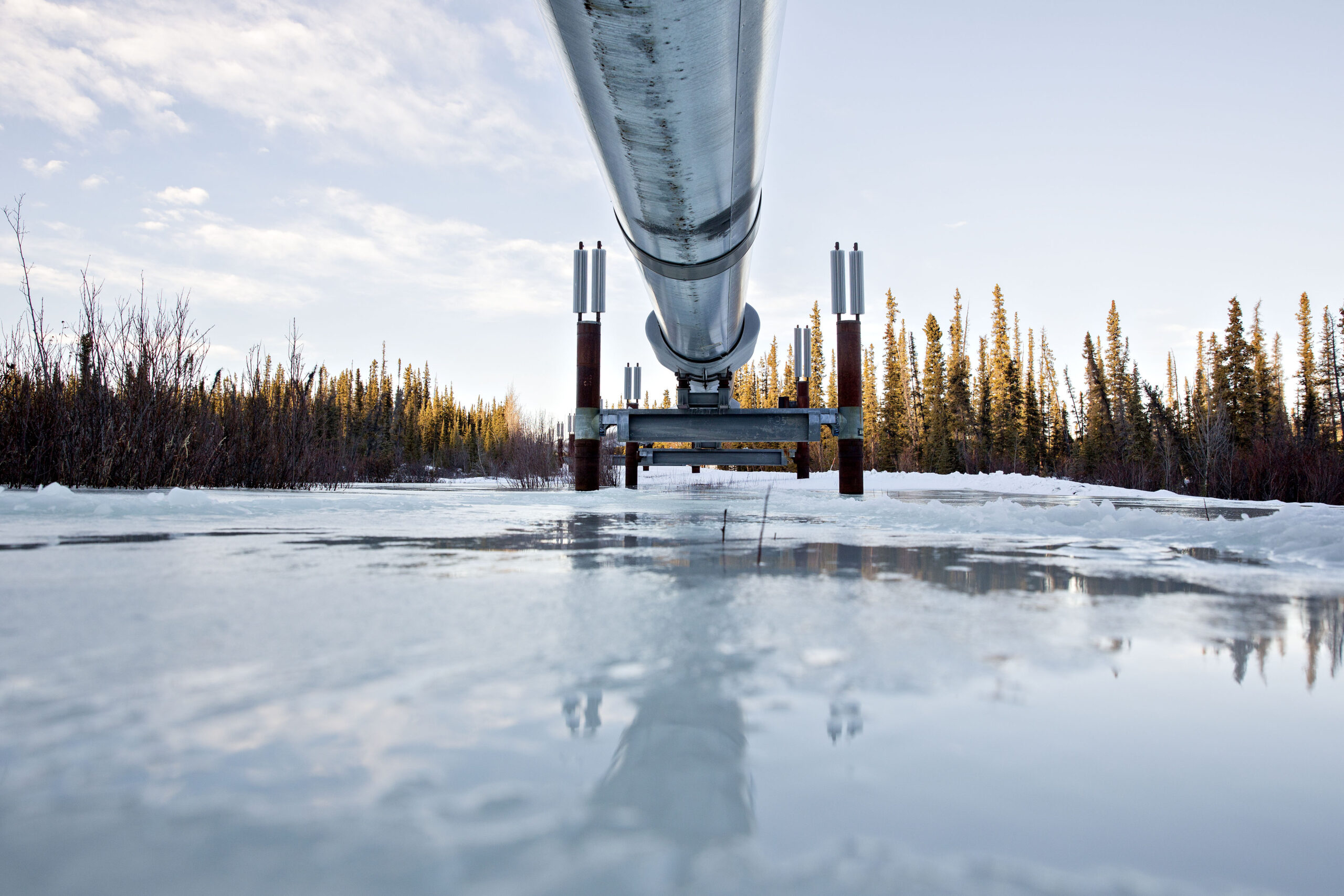
The Trans-Alaska Pipeline was designed and constructed in the mid-1970s and travels from Prudhoe Bay in Northern Alaska to the terminal near Valdez, at the head of Prince William Sound. The pipeline, either elevated above the ground or buried beneath it, hugs more than 34 major rivers and streams, sometimes running parallel to river floodplains for significant distances.
The pipeline has been praised by state officials, academics and pipeline consultants for its “robust” design intended to endure severe environmental conditions. Safeguards such as spur dikes to deflect rivers away from the pipeline anticipated the potential for erosion to damage it.
Climate change was a nascent issue at the time, after President Lyndon Johnson’s science advisory committee that made an early connection in 1965 between atmospheric carbon dioxide and warming global temperatures. Yet any discussion of climate change was absent in multiple federal environmental reviews of the pipeline.
Today, Alaska is one of the fastest warming regions on Earth, heating up faster than any other U.S. state, according to the Fourth National Climate Assessment, released in 2018. By the middle of the century, the state’s highest daily maximum temperature could increase between 4 and 8 degrees Fahrenheit.
“There was absolutely no thought given to climate impacts, future or present,” said Jim Moorman, a former attorney for the Wilderness Society who won a court order in 1970 that set the stage for more extensive environmental review under the newly enshrined National Environmental Policy Act. “All that mattered was getting it done fast and cheap.”
Dan Lawn, an engineer who worked on the construction of the Valdez terminal and southern section of the pipeline in the early 1970s, said it was impossible to anticipate the stresses put on the pipeline today by climate change.
“There was no way to foresee the way conditions have changed,” he said.
Yet even as the pipeline is being pushed harder, Lawn said the threats are being parried because of the overbuilt original design of the pipeline.
“It was constructed to withstand what was then twice the normal kinds of strain we thought there would be on the pipeline,” he said. “That, of course, has changed, and the pressure from these natural forces has increased. But because of the robustness of the design, the pipeline is still able to hold up.”
Philip Wight, an assistant professor of History, and Arctic and Northern Studies at the University of Alaska Fairbanks, who has focused his research as an academic and policy analyst on TAPS, acknowledges the pipeline as built 50 years ago was durable but cautions against overconfidence in what was robust in the 1970s holding up against the powerful new threats of today.
“It’s problematic to frame the resilience of the pipeline today in terms of the past,” he said.
He said he can’t imagine TAPS would be designed and located the same now as it was in the 1970s.
“Climate change in that period was an emerging threat but had not yet crystalized,” Wight said. “Incorporating the known threats of climate change now would require a broader swath of risk assessments.”
Years before the first section of pipe was laid, David Hickok, the director of the Sea Grant Program at University of Alaska Anchorage and a fierce defender of public lands, scolded federal regulators for failing to adequately consider the threat posed to the pipeline by the Sag and other rivers.
“Although we have no frequency data to predict floods along these rivers, they all have been observed within the memory of living men as raging torrents,” Hickok told the U.S. Department of the Interior during a 1971 hearing on the agency’s draft environmental impact statement. “Consider the impact of a flooding river with ice and upstream detritus upon either an exposed or buried pipeline under these conditions.”
In 2019, the Floods Came
For Alyeska, 2019 was the year of the flood.
The surging waters began in March when Alyeska confronted flooding on the Lowe River near the pipeline’s terminus in Valdez. The river had steadily eroded some 300 feet of bank in the direction of a section of the buried pipeline, generating a request by Alyeska to add a wall of riprap—a combination of rock and gravel—to “mitigate further erosion and exposure of the pipeline.”
Then, in May, Alyeska found itself in a pitched battle for five days to save the TAPS from the Dietrich River. The heat had accelerated snow melt from the Brooks Range that overflowed the river and surged toward an elevated section of the pipeline 37 miles north of Coldfoot, a truck stop nestled in the southern foothills of the craggy mountains along the Dalton Highway.
Records filed with the state’s oil and gas division describe the tense fight to protect the pipeline against “aggressive bank erosion” that brought the heaving river to within 80 feet—less than the length of a basketball court—of supports holding up an above ground section of the pipeline in the initial days of the fight.
“Very warm weather and channel changes towards the east side of the floodplain had caused the bank erosion,” according to Alyeska’s recap of its emergency response filed with the state. “Flows had been very high for over a week due to rapid snowmelt.”
Temperatures jumped above average for 15 days between May 15 and June 1, some days soaring as high as 13 degrees above normal—42 degrees Fahrenheit—according to data assembled by the Alaska Center for Climate Assessment and Policy.
Alyeska, an association of oil companies that includes a subsidiary of Hilcorp Energy Co., as well as ConocoPhillips and ExxonMobil, responded to the “aggressive nature of the bank erosion and continued high flows” by placing riprap between the river and pipeline “as a preventive measure to intercept and arrest the eroding bank should it continue to erode towards the pipeline.”
Yet the river kept advancing, chewing away another eight feet of bank after it was fortified with the rock until the river was less than 80 feet from the pipeline in places, according to the records. The riprap pile was increased to 185 feet in length.
A few days later, another approximately 600 cubic yards of material—200 feet long by 30 to 40 feet wide—was added to the existing barrier to stabilize about 400 feet of the water’s edge where the river was actively undercutting the bank.
The all-hands defense prevailed.
“This emergency response work stabilized the bank and repaired some of the upland buffer that had been lost,” Alyeska told state officials.
But the May heat that drove the torrent of snowmelt toward the pipeline was a prelude to a July 2019 heat wave of “astonishing intensity” as described by the NASA Earth Observatory, which unleashed record temperatures into the 80s and 90s across Alaska.
Then, in August, rain gauges registered 171 percent higher precipitation than the 30-year average when the downpours hit the headwaters of the Sagavanirktok, which means “strong current” in the Iñupiaq language, like almost never before. Rain gauges registered slightly more than two times the normal precipitation that month.
The usual rainfall total for the region is about three inches for the month, but in 2019, the total more than doubled to 6.1 inches. The water cascaded down the towering Brooks Range and poured off the hard, flat tundra; gathering in the usually languid river.
At the height of the flood, the river crested at just over 20 feet, a peak that is among the highest on record outside of the spring snowmelt season, according to data from U.S. Geological Survey monitoring stations.
That summer deluge fits the long-term pattern of increasing rain in the central and eastern region of Alaska’s North Slope, which today receives 15 to 35 percent more precipitation than it did in the early 1970s, according to records kept by the Alaska Center for Climate Assessment and Policy at the University of Alaska, Fairbanks.
The increase in precipitation can be attributed to the combination of higher atmosphere temperatures, warming oceans and decreasing summer sea ice, said Rick Thoman, an Alaska climate specialist with the climate assessment center.
“It’s important not just to look at how high the river got but consider the significance of the causative effect,” he said. “This was the result of approximately a single rain storm.”
Such downpours are increasingly being fueled by evaporative moisture from the warming of the Bering Sea, he said. The added moisture in the atmosphere supercharges the traditional summer storms experienced along the North Slope. In June 2020, Alyeska again found itself where it had begun 2019, scrambling to protect a section of pipeline buried 10 feet deep when the Lowe River roared to life and flooded near Valdez.
The onslaught of water fed by snowmelt and rain eroded the 100-foot buffer between the riverbank and the pipeline, and prompted exhaustive defensive tactics using heavy machinery. The company brought in front-end loaders, backhoes, bulldozers, compactors and trucks to wage the fight to save the pipeline, according to an application Alyeska filed with the state seeking retroactive permission for the emergency work. Crews hurriedly placed up to 2,000 cubic yards of riprap to fortify 300 feet of the eroded bank.
The fight prevented the Lowe River from washing out the pipeline, but it and other recent battles to hold back surging rivers reflects the increasing peril officials of the Trans-Alaska Pipeline say it is facing from increasing floods, a reality reflected in its recent wave of applications to perform work needed to protect it.
26 Inspections a Year May Not Be Enough
Records on file with the Pipeline Hazardous Materials Safety Administration, the federal agency responsible for enforcing pipeline safety, do not show any of the 18 breaches of the Trans-Alaska Pipeline in the last 20 years having been caused by flooding.
But the damage from a large spill is magnified because of the delicate and remote nature of the Alaskan landscape, and Alyeska admits that one involving flooding would be particularly vexing.
“Little can be done in the case of an oil spill directly into a major river during breakup, other than possible immediate burning and/or cleaning up oil that might be left on the floodplain as the river subsides,” Alyeska said in its emergency response plans filed with federal and state regulators.

The consequences were underscored by PHMSA in a 2019 bulletin warning of dangers posed to pipelines by flooding.
“Unlike hazardous liquid releases on land where it can be easier to respond to and contain spills, swift-moving river currents will carry hazardous liquids further downstream, potentially impacting much larger geographical areas and more communities,” the agency told pipeline operators.
If flood waters reached a buried section of pipeline at full strength, the force would buffet the pipe like waves slapping a sailboat on stormy seas. Rushing water could scour away the ground supporting the buried pipeline, leaving it hanging unsupported and vulnerable to collapse, while above ground sections of the pipe could be weakened if water washed away the earth anchoring its support structures.
Alyeska touts its record of safety and its comprehensive emergency response plans, including how the company would deal with a river spill. It has equipment and crews strategically placed for quick action along the route of the pipeline and a series of more than 150 valves that can be shut to stop the flow of oil to a damaged section of pipe. The company routinely deploys a helicopter to survey the pipeline.
Skimmers and booms could be deployed to corral oil contaminating a river, absorbent material could mop it up and berms could be quickly built to divert the oil into containment sites.
Officials in the Oil and Gas Division of Alaska’s Department of Natural Resources, the agency responsible for permitting pipelines on state land, say the series of mitigation projects should not be taken as cause for alarm, but rather as an example of Alyeska’s determination to safeguard the pipeline. The agency described the multiple projects to repair or improve river diversion structures as “minor.”
“Alyeska is constantly doing work to repair flood control structures back to their original design or adding additional structures,” said Sean Clifton, a spokesman for Tony Strupulis, the agency’s pipeline coordinator.
The department acknowledged the recent uptick in flooding along TAPS, but stopped short of saying the pattern was cause for concern or required any out of the ordinary response.
“Whether this trend will continue and for how long remains to be seen,” Clifton said. “It’s important to remember that rivers in Alaska have been known to be susceptible to erosion and rapid change with weather cycles like we’re having now for as long as humans have attempted to map the state.
“It’s an ongoing engineering problem that the pipeline operator will continue to address, just as they have been doing for 44 years.”
Yet the state has not done or required migration mapping to identify areas where the course of the Sag and other rivers may have changed in ways that could affect TAPS.
As part of its property lease agreement with the state for the pipeline right-of-way, Alyeska was required to submit detailed descriptions of its strategy for monitoring and maintaining the pipeline where it runs along floodplains or crosses rivers. Those records, however, are protected by confidentiality provisions that block public review.
The agency does not analyze climate trends or coordinate with Alyeska or other pipeline operators in planning for future flooding, but expresses confidence that pipeline operators maintain awareness when it comes to safeguarding pipelines.
“Prudent operators prepare for all kinds of low-probability, high-cost events as a matter of good business,” Clifton said. “Alyeska has demonstrated it does an excellent job of safeguarding its pipeline by monitoring for threats and taking preventive measures.”
Alaska doesn’t have a dedicated pipeline safety program, though the natural resources department does impose some safety requirements as conditions of permitting pipelines on state land. The state primarily relies on PHMSA for all inspections and enforcement of its 3,833-mile statewide web of oil and gas pipelines, including TAPS, under federal pipeline safety regulations. The natural resources department is part of a consortium of state and federal agencies known as the Joint Pipeline Office that provides a coordinated and consistent multi-agency approach for regulatory oversight of TAPS, Clifton said.
One of the federal regulations that applies to Alaskan and all pipelines in the United States is a requirement that they must have their rights of way inspected at least 26 times a year, at intervals not exceeding three weeks. In most circumstances, that should give an operator enough time to detect a pipeline threat, said Rebecca Craven, program director for the Pipeline Safety Trust, a non-profit watchdog organization.
“But in a situation like TAPS, where it runs so close to rivers that can change very quickly, depending on snowmelt, precipitation and temperature, it may be that a whole lot of change could occur in three weeks,” she said.
Keep Environmental Journalism Alive
ICN provides award-winning, localized climate coverage free of charge and advertising. We rely on donations from readers like you to keep going.
You will be redirected to ICN’s donation partner.
The other relevant regulations, the integrity management rules, only apply to areas where a break in the pipe could affect a “high consequence area” (HCA)—areas deemed to deserve a higher measure of protection against damage from a pipeline failure. But those remain cloaked in confidentiality, like Alyeska’s plans filed with the state.
“The challenge comes in because the public does not have access to maps or documents identifying what areas an operator has identified as an HCA, other than those identified because of population or commercially navigable rivers,” Craven said.
By keeping these areas a secret, public officials, tribal governments and landowners have no idea whether Alyeska has overlooked some important information with which only locals have a historical familiarity, she said.
“So there is a twofold benefit to making that information available: it helps the operator and regulators by ensuring a robust identification of areas of high consequence, and it builds trust with the public that the operator has identified and is properly mitigating against threats to the pipeline,” Craven said.
Alyeska Is Stockpiling Emergency Material
Over the years, Alyeska has taken additional measures to protect the pipeline from flooding by constructing simple earthen dams nearby or surrounding the pipe with wire cages filled with heavy rocks.
But new climate threats are challenging the old design standards that have kept the pipeline safe for decades. Karin Boyd, a geomorphologist and river science consultant and owner of the Montana-based Applied Geomorphology Inc, said climate change has upended long-held river flooding projections based on decades of historical data relied on to project river flooding patterns.
“What we are seeing now are changes in terms of higher river (flow) peaks, the duration of flooding and the seasonality,” she said. “This raises the question of ‘Do we need to look very carefully at whether the pipeline is more exposed now than it has been before.’”
Along with the certainty of more deluges, the floods in the last two years have moved Alyeska to seek approval from the state to construct barriers to fortify vulnerable sections of the pipeline along its entire north to south route.
Even as plans move forward for permanent structures to shield the pipeline from the Sag’s flood waters, Alyeska is stockpiling material to construct emergency dams and wants permission to build both a massive dike and a buried wall to deflect future floods on the Sag away from the pipeline.
Alyeska sought permission from the state Department of Natural Resources to stockpile 200,000 cubic yards of gravel, sand and rocks to be used to construct emergency barriers along a 67-mile section of the river above the Arctic Circle should it surge toward the pipeline again.
In addition to emergency preparations, Alyeska has blueprints pending with the state for construction of three other large, permanent flood control measures on the Sag. Since 2019, Alyeska has sought permission to construct five flood control projects on the Sag. Those projects account for nearly half of all flood control projects on the Sag since 2000.
In one proposal approved earlier this year, the company sought to erect a spur dike 355 feet long by 170 feet wide covering 1.4 acres to deflect the river from the pipeline at a point 22 miles from its starting point in Prudhoe Bay.
“This project is a continuation of efforts by APSC to protect TAPS from current and future flood events and ongoing erosion along the Sagavanirktok River through upgrades to the spur dike system,” a public notice from the Alaska Department of Natural Resources announced.
According to Alyeska’s project application with the state, the work became crucial in the wake of the 2019 flooding on the Sag that shifted the river channel toward the pipeline.
Further south along the river, Alyeska wants to construct two barriers, each almost a quarter mile long, to shield the pipeline from flooding.
One is a buried wall designed to reinforce a 1,000-foot segment of the river bank, and the other would stack a wall of boulders for 1,000 feet along another segment of the river a few miles away.
“Recent high-water events have resulted in channel changes and increased bank erosion towards the pipeline,” Alyeska reported in its application for the buried wall. “These channel changes will continue if unmitigated and threaten the pipeline integrity in a major flood event.”
‘Is This a Band Aid on the Problem?’
Still, Richard Kuprewicz, president of Accufacts Inc., a pipeline consulting firm, wonders whether all of Alyeska’s maneuvering will be enough. Three major flood projects within a 10-mile section of the Sag in the same year may signal a losing battle.
“The question that has to be asked is do they have a pretty good idea of what the future holds or is this a bandaid on the problem today,” he said, emphasizing he has not reviewed the plans.
It’s vital to understand the cumulative impact of higher flow rates and that these flow rates will continue to increase with climate change, he said. It’s possible that projects like these may be delaying the inevitable—that pipeline may have to be moved or face catastrophic failure, he said.
“I hope they are doing the right thing and have done all of the homework to prove what they are doing will work now and into the future,” he said. “Otherwise, they are left with giving the illusion that this will solve the problem when it may lead to an operation with higher risks.”

Reporter, San Diego
Inside Climate News reporter David Hasemyer is from the red rock country of Southeastern Utah where he grew up and learned to appreciate the importance responsible stewardship of the environment. He is co-author of the Dilbit Disaster: Inside the Biggest Oil Spill You’ve Never Heard Of, which won the 2013 Pulitzer Prize for National Reporting, and co-authored the 2016 Pulitzer Prize finalist series “Exxon: The Road Not Taken.” Prior to joining ICN, Hasemyer had an award-wining tenure at The San Diego Union-Tribune as an investigative reporter. Hasemyer’s newspaper work has been recognized by the Associated Press, the Society for Professional Journalists, the Society of American Business Editors and Writers. He also has been a finalist for the Gerald Loeb Award and the Robert F. Kennedy Award for Social Justice and Human Rights. PGP key: http://ow.ly/iEHN3089Gqg


