
Appalachia’s Strip-Mined Mountains Face a Growing Climate Risk: Flooding
VARNEY, West Virginia — Pigeon Creek flows through a narrow mountain hollow along a string of coal mining communities, its water trickling under the reds and yellows of the changing fall foliage.
The tranquil scene belies the devastation the creek delivered one night a decade ago as heavy rain fell on soggy soil and thousands of acres of nearby strip mines. Witnesses spoke of awakening in the dark of May 9, 2009, to the sound of rushing water like they had never heard before, entering their homes from underneath their doors.
“It was coming down out of the mountains bringing rock, trees, water and mud,” recalled Mildred Elkins, who became the lead plaintiff in a successful lawsuit with dozens of her flooded neighbors against several defendants, including Alpha Natural Resources, a coal mining company which has since gone through bankruptcy and merged with Contura Energy.
At one point, as she went to the basement to rescue some valuables, a back door gave way to pressure from the floodwater. “I heard a big old boom. That door had busted down, and water was coming through in full force,” she said. With water nearly up to her neck, she said she grabbed the steps, and pulled herself up. “I could feel my feet floating out behind me. It was scary.”
With the U.S. Army Corps of Engineers forecasting more rain and significantly increased stream flows due to climate change in a region that includes the coalfields of eastern Kentucky and West Virginia, this kind of life-and-death drama on landscapes heavily strip-mined for coal could happen more frequently in the coming years. Heavier rainfall could also mean more polluted water washing from coal mines, environmental experts say, damaging streams and aquatic life already marred by mining.
A new analysis of satellite imagery conducted for InsideClimate News by two Duke University scientists shows how the risks related to strip mining and climate change are spread broadly across the region. It found that a total of 1,400 square miles of Appalachia within the Ohio River basin has been scarred by strip mining, with the tops and sides of mountains blasted away and steep mountains valleys filled with so-called “waste rock.”
The area with the largest extent of strip-mining damage in the entire Ohio River basin—almost 500 square miles in the Big Sandy watershed, including Pigeon Creek—is also the most threatened by extreme weather related to climate change, according to the new analysis.
Straddling the state line between West Virginia and Kentucky, the Big Sandy watershed could see up to a 25 percent increase in stream flow by 2040 and 35 percent by the end of the century from climate change alone, according to the Army Corps, making hazardous flooding conditions even worse.
The other eight watersheds in the analysis, containing more than 900 square miles of mining-altered landscapes, could see stream flow increases of up to 15 percent by 2040, and one could be as high as 25 percent by then. Six of those watersheds could see increases up to 25 percent by the end of the century, the new analysis shows.
The findings suggest that long after the coal mining stops, its legacy of mining could continue to exact a price on residents who live downstream from the hundreds of mountains that have been leveled in Appalachia to produce electricity.
“We have lost the forest that helps retard the rapid runoff that comes from surface-mined lands,” said Jack Spadaro, a former top federal mine safety engineer who works as a consultant for coalfield residents, workers and their lawyers. “And the coal that is sold from most of these mines goes into coal-fired power plants, further contributing to the negative effects of climate change.
“These things together don’t bode well for this region. It’s going to have an effect for hundreds of years.”
Overlaying Climate Risk on Maps of Mined Land
To assess the threat posed by climate change in strip-mined Appalachia, InsideClimate News obtained digital mapping files from a 2017 climate change report by the Army Corps on the Ohio River Basin. The document for the first time put 2,400 urban and rural communities across, from southwestern New York to Tennessee, on notice that the 981-mile Ohio River and its many tributaries would face increasing rainfall and flood risks.
Duke graduate students Megan Ossmann and Alexander Yoshizumi overlaid satellite imagery of Appalachia on the Army Corps watershed maps, highlighting areas like Pigeon Creek that had been both heavily strip mined and forecast for significant increases in rainfall and stream flows.
Communities in the mountainous coal-producing areas of Central Appalachia will likely “experience the negative impacts of mountaintop mining even further,” said Ossmann, who now works for the U.S. Environmental Protection Agency’s Chesapeake Bay Program.
The Army Corps study did not take into account land-use changes, like mining or urban development, which can affect rain runoff, when it made its stream flow forecasts, said Kathleen D. White, who oversaw the report for the Army Corps. She said the new findings from the Duke researchers are “very interesting” and show the potential for “a more detailed study of these areas using more up-to-date climate-impacted hydrology and incorporating observed and projected land use conditions.”
Previously, White had cautioned that Army Corps findings were already out of date because of the pace of climate change. “This isn’t something just in the future,” she warned.
What Studies Warn About Strip Mining and Flood Risk
Across Appalachian coal country, mining companies, flood victims, environmental advocates and academic researchers have debated the extent to which strip mining contributes to flooding, sometimes in court. Flooding damage can come in different forms—collapsed impoundments of coal wastes, for example, or water flowing off denuded landscapes where stormwater management systems failed, or landslides.
The Duke mapping included not only areas where coal was extracted, but also valley fills of waste rock, which can slump or slide with heavy rain.
There is no question in Spadaro’s mind that mining makes flooding worse, based on his decades of investigating flooding disasters. Often, he said, what comes out in court is that mining companies failed to follow the rules designed to minimize flooding risks.
Others looking broadly across the Central Appalachian landscape paint a more nuanced picture, saying the region’s hydrology is extremely complex, and that valley fills can actually store rain water and reduce stream flows.
“There aren’t a huge number of studies, maybe a dozen,” that examine the question of flooding and surface mining, said William C. Haneberg, the Kentucky state geologist and a University of Kentucky research professor. “If you were to pick a really general conclusion, in broad terms, mining results in an increase in peak discharges during storms,” he said.
The Army Corps acknowledged at least as far back as 2000 that strip mining with valley fills could increase runoff. And a major environmental impact study on mountaintop mining published by the EPA in 2011 reported that storms can produce greater stream flows in watersheds with mountaintop mining and valley fills compared to unmined watersheds, especially in heavier rains.
For their part, companies have argued the floods are “acts of God,” or that regulations work to minimize flooding—at least since the 1977 Surface Mining and Reclamation Act was passed, requiring stormwater to be managed at surface mines.
William B. Raney, president of the West Virginia Coal Mining Association, declined to answer questions about mining practices, flooding and climate change. His counterpart in Kentucky acknowledged mining could increase runoff but said not unreasonably so.
“Every use of property contributes to flooding if it increases impervious surface area in any way,” such as parking lots, roads and other development, said Tyler White, president of the Kentucky Coal Association.
He argued that coal mining does not create “a risk of harm,” while conceding that there would be no way to prevent “any contribution to flooding in the steep slope areas of eastern Kentucky” without stopping “all industrial or commercial development, something no one would reasonably contemplate, and something that would be detrimental to the lives of people living in eastern Kentucky.”
Mining Standards Not Keeping Pace with Climate Change
The rules that govern stormwater management from strip mining and the engineering design of those mine and their valley fills and containment ponds are based on historical rain patterns, not future predictions.
Nicolas Zegre, a West Virginia University hydrology professor and director of that state’s Mountain Hydrology Laboratory, said risks are exacerbated because mining standards are not keeping pace with climate change.
“Precipitation is indeed increasing,” Zegre said. “From a conceptual perspective, I would expect to see more peak flows coming off these surface mines.”
Valley fills store water, and “climate change is putting more water on top of water already stored there,” he said, raising risks near headwaters, “where most of our communities live and are vulnerable.”
Federal authorities that regulate surface mining do not require states to factor precipitation changes from global warming into engineering designs, said Terry Fletcher, spokesman for the West Virginia Department of Environmental Protection.
Still, he said, “since 2004, West Virginia’s mining program has been requiring constructed stormwater management designs to control runoff on surface mines and imposes a no-net increase threshold for runoff during all phases of mining.”
In Kentucky, surface mines are engineered “to the best available standards to minimize increased runoff and stream flooding,” said John Mura, spokesman for the Kentucky Energy and Environment Cabinet.
But concerns persist about the adequacy of erosion and sediment controls. “With the larger and more intense storms coming, you could have those controls fail,” leading to more flooding, said Joe Pizarchik, a lawyer from Pennsylvania who ran U.S. Office of Surface Mining and Reclamation, the agency that oversees enforcement of the 1977 surface mining law, during the Obama administration.
Acidic water runoff that flows from strip-mined areas into valley fills and dissolves rock from the inside, likely weakening them, is also a potential risk that could grow with climate change, increasing the potential for landslides during storms in the future, said Duke University Professor Emily Bernhardt, who studies watershed biogeochemistry.
Haneberg, the Kentucky state geologist, said those concerns are valid. In Kentucky, he’s researching the stability of valley fills and “in some we are seeing evidence of failure.”
Polluted Water Is Coming Through the Valley Fills
Then there is the possibility that climate change could worsen mining-related water pollution in a region where some streams already run traffic-cone orange from acid mine runoff.
Because valley fills can act like sponges, they can keep streams that might otherwise dry up or be reduced to a trickle with a strong flow longer into the year, said Bernhardt, the Duke University professor. While that may sound good, water coming from the mines and through the valley fills is polluted, she said. She has been part of teams that have documented the salt-laden and alkaline pollution from mountaintop removal mines.
“Every mountaintop mine in Appalachia no matter how old it is, is exporting really salty, high alkalinity waters, and it’s not declining,” she said.
Climate experts also expect periods of longer droughts in the future, between heavy rains, and Bernardt said that could be a serious problem, too.
“I worry that with the droughts, which are supposed to be more prolonged and extreme, almost all the water we are going to see (in streams) will be derived from valley fills, and will be laden with mountaintop mine pollution,” resulting in greater harm to aquatic life, she said.
‘One Home Came Floating Down the River’
At least half of the Pigeon Creek watershed has been disturbed by mining. That was Jack Spadaro’s estimate in late October as he stood atop a huge, treeless strip mine above the creek. “All of this was a forested mountain,” he said. “What you need to know is the mountain here was 300 feet higher.”
He’s the former director of the National Mine Health and Safety Academy, which trains mine safety officials. He lost his job after he blew the whistle on what he called a whitewash by the Bush administration of an investigation into another major mining disaster, the Martin County, Kentucky, coal slurry spill in 2000.
Mining companies since 1977 have an obligation to reclaim the land they disturb, and that is intended to reduce flooding risks. But he said when he investigates flooding near mines, he often finds that companies take engineering or construction shortcuts, including miscalculating how a mine’s features will respond to rain, or failing to install adequate water controls on what are large-scale alternations of natural landscapes.
Forests could take hundreds of years to return, he said. “You have these massive areas, in the millions of acres, that are not rejuvenating,” Spadaro said.
In the last 20 years, he said, there have been a series of Pigeon Creek flash floods. Hydrologists who studied the May 2009 flood calculated that mining had caused the creek to carry 51 percent more water then compared to pre-mining conditions. They presented that in Mingo County Circuit Court in a trial where the jury gave awards to 45 plaintiffs ranging from $1,050 to $100,000 each, according to court records. That triggering confidential settlements with dozens more.
The same day that Mildred Elkins was scrambling to get out of her basement alive, one thunderstorm after another dumped six inches of rain in 14 hours on steep hills and narrow hollows of eastern Kentucky, about 60 miles west. Small creeks and streams swelled and overflowed, and Quicksand Creek in Breathitt County, Kentucky, rose to its highest level in memory. Authorities rescued hundreds of people from flash floods.
“It was a scary time when you could see that water coming,” recalled James Holbrook, who still lives on the same farm that was flooded by a raging Quicksand Creek. The water “was on top of the telephone line,” he said. “A lot of people lost their homes. One home came floating down the river.”
Holbrook was among about 70 plaintiffs to settle a lawsuit from that flood. In that case, the expert witness working with Spadaro calculated that a strip mine in its headwaters boosted runoff by nearly 30 percent.
Holbrook’s attorney, Ned Pillersdorf, said he could not disclose the terms. But he said the case was one of four in recent years that he handled, representing about 300 clients, all with similar circumstances—heavy rain falling on open surface mines that caused flash flooding, wiping out communities that were fairly impoverished.
“The game plan was to push these cases as fast and hard as we could,” Pillersdorf said. “These people were basically homeless.”
“After they striped the mountain down, there was nothing left to catch the water,” Holbrook said of the mining. “If it happened once, you are always concerned it can happen again.”
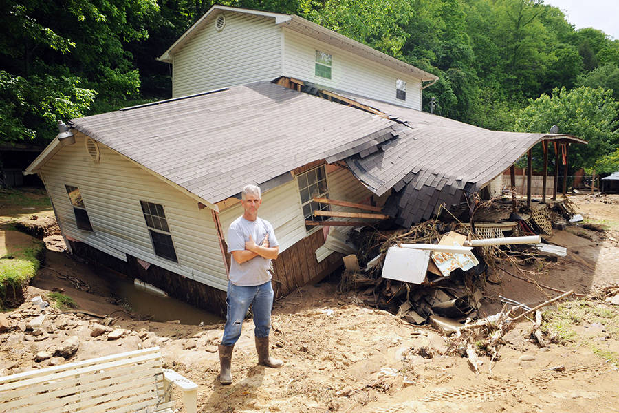
Top Photo: Floodwater that swept down Pigeon Creek hit Eddie Fields’ home in Pie, West Virginia, and many of his neighbors’ homes in May 2009. Credit: Logan Banner file photo


