
Restoring Watersheds, and Hope, After New Mexico’s Record-Breaking Wildfires
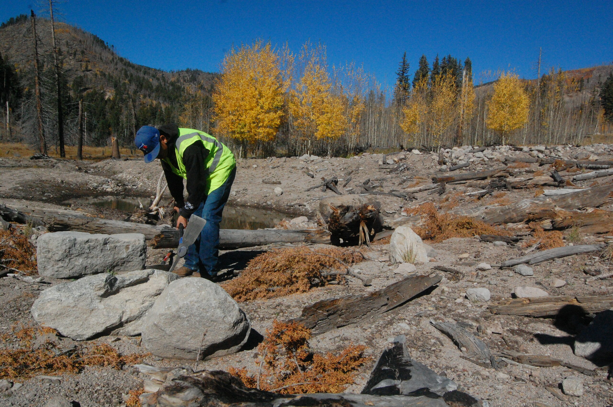
GALLINAS, N.M.—On a warm August day, a small crew arranged charred logs and rocks into a structure to slow flooding below a dammed pond in New Mexico’s Sangre de Cristo mountains. Just three months earlier the state’s largest-ever wildfire raged through here, burning over 340,000 acres and leaving behind thick ash, charred debris and unstable, water-repelling soils.
Conrad Greaves, formerly the restoration and monitoring coordinator for Hermit’s Peak Watershed Alliance (HPWA), pointed to the hillside above, dotted with burned Ponderosa pine stumps. The last big rain flowed off its slopes and surged through the dam spillway with such force it shot small boulders 40 feet into the meadow, he said while directing the group of volunteers and HPWA volunteers restoring the valley.
“That kind of gives you an idea of how much energy the floods are having,” he said.
Two volunteers put the displaced boulders to work, fitting them into a triangular baffle.
The structure will both catch sediment and redirect the flows to spread across the meadow, Greaves explained, preventing water from carving deep grooves into the slope. And once the water is dispersed, it can slow down enough to permeate the scorched soil and create a sustained flow over time instead of torrential floods, Greaves said.
Lea Knutson, executive director of HPWA, said their philosophy is “every inch of ground is important.” Over time, she said, all the ground they work on has an impact.
In the valley bottom, thick grass grew up through mounds of charcoal. Monarch butterflies and bees visited thistles and asters. It’s all evidence that the landscape is repairing itself, said Meagan Larson, HPWA restoration assistant. After the burn it was a “moonscape,” but wildflowers and woody plants like oaks have slowly grown back, she said. This meadow can “absorb the velocity of the rain events,” she said, making it and similar landforms crucial to watershed recovery. “We just need to protect it so that it’s able to do its job.”
The Hermit’s Peak-Calf Canyon Fire grew out of a U.S. Forest Service (USFS) prescribed burn that spread rapidly in dry, windy conditions in early April. While the blaze destroyed homes, farms and forests, the floods that followed have been even more damaging. Four people drowned this summer in the wildfire-exacerbated flooding that also inundated many homes.
Together, the fire and the flooding destroyed hundreds of homes, according to New Mexico congressional representatives. Denuded mountain slopes were carved with deep gullies. And the Gallinas River, the critical source of water for the nearby city of Las Vegas, New Mexico, was choked with sediment and contaminated with ash, leaving the city scrambling to replace its water treatment system, imposing water restrictions and distributing bottled water to residents.
Alicia Gallegos came up to volunteer with HPWA on weekends throughout the summer. She grew up in Las Vegas, and the mountains were her “playground” where she would camp and fish. The fire “broke my heart,” she said. During the blaze, she and her mother evacuated their home in Las Vegas for a couple weeks because of her mother’s respiratory issues. After their relocation, and the threats of fire and floods, running out of water was “like another kick in our butts,” she said.
To avoid future flooding and water contamination, the area has an urgent need for landscape-wide restoration. While federal agencies undertake many of their repairs with heavy machinery, several local organizations, including the HPWA, are using small-scale, nature-based approaches to restore the Gallinas watershed. These hands-on efforts are offering hope for both the landscape and the community.
Knutson was evacuated for five weeks during the fire, and her property at the foot of Hermit’s Peak was one of the first to burn, though her home was saved. Yet she remains positive, and watches carefully for opportunities to recover from the fire and flooding.
“Flood events could turn into restoration events,” she said, with small dams trapping sediment carried by rain flows to fill in eroded channels.
The HPWA’s approach to engineering involves building structures with materials available on site, such as stones and fallen timber, and working with natural processes like flooding by collecting sediment.
Knutson envisions thousands of simple, hand-built structures like baffles and dams throughout the drainages above the Gallinas to slow the flow of water into the river. “I would just love to see hundreds of people out there building these low-tech structures with logs and rocks, because they don’t require a lot of maintenance in the long run.”
Her organization is working at several sites throughout the Gallinas watershed. While federal and state disaster relief, which typically have restrictions on the use of funds, complex application processes and long timelines, have been slow to reach local communities, Knutson said her organization has tried to respond quickly to their needs. “We were the first organization on the ground doing land restoration,” like reseeding on private land, she said. “There’s a pretty big gap there for private landowner assistance.”.
The HPWA works primarily with such landowners. Brice Harvey owns the meadow the crew is restoring. On the ridge above the pond, the blackened remnants of his trailer home are rusting away. He and his wife live in Santa Fe and bought the property in the Sangre de Cristo mountains to connect to her family’s deep roots in the area. She and Harvey were engaged nearby. The fire hit their property on their anniversary.
“It’ll never be the same,” he said. The fire burned at such a high intensity that the Ponderosa forest is just “charred sticks.”
Harvey said he tried to apply for FEMA disaster relief funding, but was told he wasn’t eligible. FEMA only covers damage to a primary residence. So he’s thankful that the HPWA has been a partner in rehabilitating his land.
Such partnerships—there are several nonprofit and community groups helping private landowners through the wildfire’s burn zone—are crucial given the scale of the devastation.
Santa Clara Pueblo Lends Hard-Won Experience
One group offering critical expertise for fire and flood recovery is the tribe of the Santa Clara Pueblo.
The New Mexico Forestry Division turned to the tribe, which has endured and recovered from multiple devastating fires, to help repair the upper Gallinas watershed.
In 2011, the Las Conchas wildfire—then the largest wildfire in New Mexico history—burned tens of thousands of acres of the pueblo, which extends from the peaks of the Jemez Mountains near Los Alamos to the Rio Grande in the northern part of the state. It was the third fire in less than two decades to scorch the Pueblo’s land, all of which started on adjacent federal lands.
In total, over 80 percent of the pueblo’s forests have burned. Subsequent flooding destroyed roads, bridges, water control facilities and popular fishing and recreation sites the tribe relied on for revenue.
Santa Clara Canyon was integral to the tribe’s livelihood, serving as both a grocery store and a pharmacy, where members harvested plants and animals, said Daniel Denipah, director of the pueblo’s forestry department.
When the fires and floods devastated the canyon, they threatened cultural practices and even language, he said. “If the kids aren’t learning the language,” like place names in Tewa, the tribe’s language, “and they’re not able to apply that out in nature, then it makes it more difficult for us” to maintain traditions, he said.
Denipah is from the nearby Ohkay Owingeh Pueblo, and his wife and children are members of the Santa Clara Pueblo, which drew from its own traditional ecological knowledge in designing plans for flood mitigation, erosion control and replanting.

The canyon, which only reopened to Santa Clara Pueblo members in 2021—10 years after the Las Conchas Fire—shows what the community of Las Vegas can expect as they begin restoring their lands from last spring’s Hermit’s Peak-Calf Canyon Fire.
On a fall day deep in the canyon below the confluence of Turkey Creek and Santa Clara Creek, terraces lead to a small pond carved out of the gravel and sand deposited here by repeated post-fire floods. Chicoma Mountain, sacred to the Santa Clara Pueblo, rises to the north. Bordering the pond, a dense grove of young aspens—which have sprouted since the fire—was one sign of progress.
Golden aspen leaves twirled in the breeze as forestry project manager Garrett Altmann planted a variety of conifer seedlings around the pond. Altmann placed branches around the seedlings to help trap moisture and provide microhabitats for insects. Woody debris also provides shelter for small animals, which in turn become food for predators like bobcats and mountain lions, Altmann said. This summer the canyon hosted a mother bear and two cubs, and it’s also home to deer and thousands of elk in a resident herd.
Using damaged or burned trees in their restoration projects is “consistent with Indigenous knowledge of maximizing your local resources, and limiting foreign materials,” said Altmann, who is not a Pueblo member.
When the tribe began restoring the canyon, they referred to federal post-fire recommendations for structures like rock dams to stabilize tributaries. But the canyon’s volcanic soil lacked boulders, Altmann said, so they turned to the resource they had in “unlimited supply”: burned timber. They began to “innovate and evolve some of those structures,” replacing rocks with logs, he said.
It’s an “insurmountable task” to replant all the burned areas, Altmann said, so their goal is to strategically seed where trees have the best chances of surviving. Once these seedlings mature into trees, they’ll help restore the floodplain by holding soil in place and shading the creek. And since they’re at a high elevation, gravity will help disperse new seeds the trees produce to reseed areas downstream, Altmann said.
One question Altmann uses to guide restoration is, “How can we build it to be more resilient” than it was before? Part of the floodplain was buried under debris, which covered up a wetlands complex. Now they have the opportunity to create ponds and other structures to encourage future floods to spread out erosive surges, and deposit sediment over a broad area.
A decade after restoration began in the Santa Clara Canyon, major work remains. Efforts to rebuild recreation sites, restore the creek to a natural state and return native trout are ongoing. And the risk of flooding continues: This summer a storm inundated the canyon and washed out parts of the road.
But the tribe is lending its hard-won experience to restoration in the Gallinas River watershed recovering from this year’s fire. A team of sawyers from the Pueblo will carry out contour felling, cutting down burned trees and placing them perpendicular to the incline of the slope. The logs then become natural dams that slow down the runoff of water, and allow the area sheltered by them to be filled and reseeded.
Denipah has seen it all—the fires, floods and the recovery process at Santa Clara. “We understand the impacts, and not just this loss of trees and property,” but impacts to the whole community, like the people of Las Vegas are experiencing, he said. “The thing is to keep trying no matter how small a project might be,” he said. “Don’t give up.”
From the Soil to the Trees, Recovery Requires Grassroots Efforts
For both human and natural communities in Las Vegas, the road to restoration is long, and the outcome unknown due to climate change, but, where intense fire destroyed all vegetation, conserving the soil will be a critical first step, said Tomasz Falkowski, an assistant professor of forestry at New Mexico Highlands University in Las Vegas. A USFS assessment found that in the burned area closest to Las Vegas, 21 percent of soils, including large swaths of the Gallinas watershed, burned at high severity, and 28 percent more burned at moderate severity.
Keep Environmental Journalism Alive
ICN provides award-winning climate coverage free of charge and advertising. We rely on donations from readers like you to keep going.
In the longer term, climate change will have a big impact on post-fire recovery, Falkowski said, because it can scramble historical patterns. High-intensity fires and long-term drought will likely change the forest composition in these mountains, he said. In some places where tall Ponderosa pines once dominated, they’ll be replaced by shrubby piñon pines or scrub oaks. And it could take years to see what the new landscape will be.
“We’re going to be talking decades” for the forest ecosystem to come back, Falkowski said, “if it does at all.”
Human intervention will be vital to those efforts to revive forests and, given the challenges, Falkowski said, no single solution, like tree planting, is sufficient. “The system as a whole” needs to be addressed.
Falkowski believes in the philosophy of reciprocal restoration—“if we take care of the land, the land will take care of us.” It’s crucial for restoration efforts to also consider social and cultural impacts on humans, he said.
For Gallinas landowner Bryce Harvey, recovery efforts on his property are helping him, too. For his community, he said, “it’s like our therapy to go up there and work on the land.”
HPWA volunteer Gallegos agrees. While she cried when she first saw the burn area, she’s since observed the natural environment rebounding. And, she said, “I know coming out here every week that I’m helping.”


