
Community and Climate Risk in a New England Village
WOODS HOLE, Mass.—When a Nor’Easter threatens this storied Cape Cod community, intrepid villagers lean into the wind. Kids hop in their dinghy boats for a quick sail before the hurricane arrives—worth it to earn bragging rights with friends, even if they never left the harbor.
Pam Harvey speaks from experience. A third-generation Woods Hole resident, the former environmental lawyer has taken her share of dinghies out into stormy winds and lived to tell the tale.
Woods Hole has stood the test of time for nearly 150 years as a whaling, shipping and fishing village and now, a center for oceanic research. But its greatest challenge may yet be ahead, as storm surges and flooding become more regular with climate change.
Adapting to sea level rise and intense storms has already faced more than a little resistance, even in this science-savvy coastal community where many residents understand the threat posed by climate change with deep expertise.
Keep Environmental Journalism Alive
ICN provides award-winning climate coverage free of charge and advertising. We rely on donations from readers like you to keep going.
Harvey, one such local, hopes a new resiliency plan will strengthen the town before the next storm takes their sailboats right off the beach. “It’s not going to be the same,” said Harvey. “Even though [families] want to stay forever.”
Harvey is the granddaughter of Ethel Browne Harvey, who began working at the Woods Hole Marine Biological Laboratory (MBL) in 1907. Woods Hole transitioned to a marine science hub in the late 19th century with the establishment of MBL and other ocean science institutions.
Browne Harvey was known for studying embryonic cell cleavage in sea urchins, some of the earliest research in stem cells. She became a trustee of MBL, a private, nonprofit institution affiliated with the University of Chicago, and raised her family in the village. Many Woods Hole families can claim similar lineage to the Harvey’s, with descendants of marine scientists still living in the area.
That’s why maintaining the character of the village is important to residents, and is at the forefront of ResilientWoodsHole, a climate adaptation project developed with the Woods Hole community and its surrounding research institutions to assess the risks of flooding from sea level rise and storms. This resiliency plan is an extension of Massachusetts Office of Coastal Zone Management’s Coastal Resilience Grant Program, which supports towns to start planning and implementing climate change resiliency projects.
The first phase of the project included assessing the vulnerabilities of the village’s research institutions, including the Marine Biological Laboratory (MBL), the National Oceanic and Atmospheric Administration’s Northeast Fisheries Science Center (NOAA), and Woods Hole Oceanographic Institution (WHOI, affectionately pronounced “hooey”).
The project assesses climate change vulnerabilities throughout the town, including those found in 879 residences and 28 businesses. Nearly 2,000 structures were assessed overall, the remainder belonging to the research institutions and 10 federal buildings owned by the U.S. Coast Guard.

In the most recent report released in September, residents provided feedback on proposed adaptation plans. The response came in part from a “Community Vision Workshop” hosted in February 2022, where results of the initial vulnerability assessment were presented and residents could see which areas would be most at risk from sea level rise and storm flooding. What the town and the research institutions think are the most important places to protect can be at odds, so choosing an adaptation plan requires an ongoing conversation.
Maintaining the historic character of the village is the first priority of the community. Villagers also support “nature-based” solutions that use open space and enhance existing ecosystems. This might mean preserving marsh habitat to increase flood resilience and building up natural sand dunes. But these natural solutions may not always be appropriate, said Joe Famely, a senior climate resiliency specialist with Woods Hole Group, the engineering consultant for the project.
“We should be asking about the risk tolerance of the community,” said Famely. Are residents willing to elevate a road to protect against seasonal storm flooding, or do they want to raise the road high enough to protect from the biggest hundred year storms? If nature-based solutions are determined to be insufficient based on projected flooding risks, the next steps in the resiliency plan emphasize protecting and maintaining infrastructure with hybrid solutions.
Those solutions could include, for example, elevating a road or adding a seawall to redirect floodwaters. Ultimately, adapting to climate change is all about timelines and how far into the future communities are willing to look.
Harvey said it can be hard for people to think about what climate change will mean for them and what they will do to prepare. Woods Hole has had catastrophic hurricanes in the past, most recently with Hurricane Bob in 1991. So residents understand the impact storms can have on the village. But seeing detailed plans for how they might actually begin to adapt “puts a whole new gloss on things,” said Harvey.

The capacity of villagers to make changes to their homes, businesses or roads is smaller than large institutions like NOAA or WHOI, said Harvey. These institutions have been thinking about adaptation for years, have the expertise of climate and ocean scientists, and are planning long term resiliency projects costing millions of dollars.
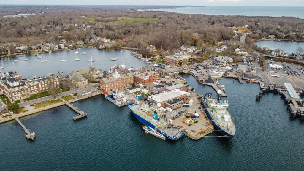
WHOI is conducting a $7 million design process to propose a new dock at the Iselin Marine Facility that will make it resilient to flooding and protect an existing research building that now sits partially atop the dock. Currently, the dock is a patchwork of black asphalt bandaids over concrete slabs that have cracked or weathered over the last 50 years. All told, the construction will cost about $100 million on this one-acre site, said Robert Munier, the vice president of WHOI facilities and marine operations. It’s a big price tag but it is “mission critical,” Munier said.
The dock extends into deep water that allows large research vessels ranging from 250 to 275 feet to tie up. In the center of the dock is a training “well” where scientists practice scuba diving and maneuvering remote-controlled aquatic robots.
There’s the ship that carries Alvin, the beloved deep-sea submersible. Another that carries “meso-bot,” which takes measurements in the ocean’s mesopelagic layer or “twilight zone.” Ships here are bound to research projects in Puerto Rico, Iceland and elsewhere. Yet because WHOI is a private, nonprofit institution, said Leslie-Ann McGee, the director of special projects, it can be difficult to access federal infrastructure money needed to carry out the proposed design. Completing the resiliency plan assessment through Resilient Woods Hole solves that problem.
Across the road from WHOI’s research dock is the Marine Biological Laboratory, where Harvey’s grandmother worked. MBL is facing its own funding challenges as it prepares to update its campus in accordance with the priorities laid out in Resilient Woods Hole. MBL research buildings, like Lillie Laboratory, are full of ongoing experiments that receive federal funding, said Diana Kenney, the associate director of communications at MBL. So not only is infrastructure lost during flooding, but in the long term these expensive experiments with live marine animals could be at risk.
Lillie is the oldest laboratory on MBL’s campus, with various sections built in the 1920s and ‘30s. It’s a three-story brick building filled with lab space, a 500-seat auditorium, and a library. Lillie Lab is adjacent to Eel Pond, a lagoon protected from the larger harbor by a spit of land where the laboratory and WHOI’s research dock sit. The first floor and basement flooded most recently in 1991, with Hurricane Bob. This is more of a problem for Lillie because the building’s mechanical systems are at ground level and have been inundated by Eel Pond storm surge in the past.

“Good planning,” Paul Speer, the chief operating officer at MBL, said with exaggerated irony. He pointed to a small extension at the back of the building where the mechanical systems are housed. Inside, Speer walked down a narrow hallway in the building’s basement lit with fluorescents. Exposed pipes and wires ran down the length of the hallway, and one bunch veered off into a dark room that houses the telephone system and electrical switches. All of this equipment is at risk of becoming inoperable if the building floods.
It’s a matter of when Lillie will flood next. The question, said Speer, is how to bridge the gap between now and when the building renovation is completed. Currently, staff moves ground floor equipment upstairs whenever they are within a five-day storm cone, said Speer. This includes six freezers that hold research samples at minus 83 degrees Celsius and weigh over 600 pounds each. There are also metal flood gates that staff close over the lab doors to help prevent water from rushing through the bottom. MBL is seeking funding for a big renovation of Lillie that will move these mechanical, electrical and plumbing systems to the second floor, and bolster the first floor so that it can take on flood water. The design also includes renovating another wing of the laboratory for a new imaging center for microscopic research.
For MBL, the Woods Hole climate resiliency plan is non-negotiable. They need to take steps to secure their labs, research buildings and housing. Unlike WHOI and NOAA that have some parts of their campus upland, MBL “literally has nowhere else to go,” said Speer.
MBL’s campus sprawls through the village of Woods Hole. The research communities are intertwined with the local residents, many of whom are like Pam Harvey and have long roots here. Woods Hole is a relatively wealthy and highly educated community. The people who live here are not, for the most part, climate skeptics. Even so, many residents are anti-development and attached to the fishing village character with local shops and cedar-shingled buildings.
For a residential community like Penzance Point, where Harvey’s grandparents purchased a house on higher ground after a 1938 hurricane, residents may be able to tolerate some flooding. Hurricane predictions have improved since Harvey’s grandparents’ time, when her grandmother drove almost six miles round trip to Nobska lighthouse just to see whether the hurricane flag was raised. Residents can evacuate when a big storm comes and return after flood waters recede. On the other hand, a million dollar research building with experiments and samples can tolerate no level of flooding.

In 2030, a 1 percent chance of a storm in any given year (what FEMA flood maps are based on) could inundate Bar Neck Road, the main street into the village, with 9.3 feet of water. The critical elevation, or when flood water causes the road to become unusable or significantly damaged, is about 4 feet. By 2070, this area could receive more than 14 feet of flooding, according to projections related to sea level rise in the climate change vulnerability assessment conducted by the Woods Hole Group for the resiliency project.
However, the Penzance Point community may not need to or have the capacity to build the road to withstand a 2070, 1 percent storm because the chances are so low and the residential area would likely be evacuated anyway. It comes down to “what’s physically possible in that space, and what are the goals of the community in terms of risk reduction,” said Famely.
One high-priority area identified by residents is Mill Pond. Mill Pond is separated from Eel Pond by Millfield Street, two lanes of asphalt that is a major thoroughfare for both full-time residents and students who use it to travel between work at the research labs and home. It is also prone to flooding. And because this area has a combination of homes, institutional buildings and a sewer lift station operated by the town of Falmouth, the proposed adaptation pathways could require more than nature-based solutions. The community may consider restoring the historical connection between Eel and Mill Ponds to prevent water from building up on the Mill Pond side. They may also build a seawall to direct floodwaters away from homes, and flood-proof the sewer lift station, which was temporarily shut off after 2018 seasonal storm flooding.
Whatever the town decides together, it is a story of timelines. By the time WHOI secures funding for the dock project or a homeowner elevates their house, the next storm could have already caused devastation. Adaptations may ramp up in seriousness as climate change progresses, but the town also wants to be ready in the interim. Having a plan is the first step. Even if residents haven’t fully grasped what the future holds, said Harvey, “people really did accept that…just doing nothing was not going to be a path we should take.”
<div class="post-author-bio">
<div class="image-holder">
<img width="300" height="300" src="https://insideclimatenews.org/wp-content/uploads/2022/06/PXL_20210812_140047857-300x300.jpg" class="attachment-thumbnail-medium-square size-thumbnail-medium-square" alt="Hannah Loss" srcset="https://insideclimatenews.org/wp-content/uploads/2022/06/PXL_20210812_140047857-300x300.jpg 300w, https://insideclimatenews.org/wp-content/uploads/2022/06/PXL_20210812_140047857-150x150.jpg 150w, https://insideclimatenews.org/wp-content/uploads/2022/06/PXL_20210812_140047857-64x64.jpg 64w, https://insideclimatenews.org/wp-content/uploads/2022/06/PXL_20210812_140047857-600x600.jpg 600w" sizes="(max-width: 300px) 100vw, 300px">
</div> <!-- /.image-holder -->
<div class="content">
<h3 class="author-name">
<a href="https://insideclimatenews.org/profile/hannah-loss/">
Hannah Loss </a>
</h3>
<h4 class="profile-subtitle">Fellow</h4>
Hannah Loss is a journalist based in New York City and Boston with interests in ecology, infrastructure and agriculture. She is a graduate student at New York University’s Science, Health & Environmental Reporting Program. Previously, she worked in science documentary and radio production and science conference programming. She studied environmental studies and English at Tufts University.
</div> <!-- /.bio -->
</div> <!-- /.post-author-bio -->


