
Forecasters Tap High-Tech Tools as US Warns of Another Unusually Active Hurricane Season
In and around Panama City, Florida, Judy Dickey is the “weather lady,” a credential she earned working for three decades as a meteorologist at local television stations.
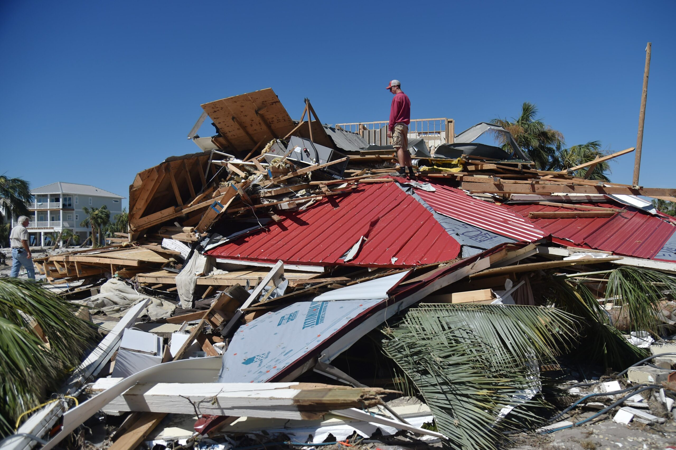
So when Dickey decided to ride out what was at the time a Category 3 Hurricane named Michael in October 2018, she said her adult son and a group of friends who had come together figured all would be well. As they went to bed that night, Michael churned northward over the Gulf of Mexico.
“People are kind of weary of … ‘it’s gonna be death and destruction,’ but it never is,” Dickey recalled of the mood at the time. “That was the mindset going into hurricane Michael. ‘It’s gonna be a three, we’re going to flood the same as always. So everybody makes sure you’re someplace safe. You know, high.’”
Dickey, along with many thousands of others on the Florida panhandle, awoke the next day to an unexpected situation. Michael was rapidly intensifying to what the National Weather Service would ultimately classify as Category 5, a storm that would cause catastrophic damage from 160 mile-per-hour winds and nine to 14 feet of storm surge.
“We’re like, ‘Oh, dang it,’” Dickey said, remembering how the gravity of the situation sank in. “‘Oops.’ And at that point, you know, it was the morning and it was fixing to hit. And we’re like, ‘OK, well, we’re just going to hunker down,’” which she said they did with two cats, a dog and a baby, for what the Air Force veteran described as the second-scariest day of her life. The first? A Scud missile attack in Saudi Arabia.
Four years later, Michael remains a poster child of what appears to be an increasingly familiar phenomenon with hurricanes—a rapid intensification that happens faster than even long-time residents can imagine and can be very hard to forecast.

Hurricane experts have gotten very good at forecasting the path or track that hurricanes, also known as tropical cyclones, take as they spin across the ocean, making it easier for emergency managers and the public to make smart, life-or-death decisions on when to evacuate and where to go as a hurricane approaches.
At the same time, hurricane experts say forecasting storm intensity remains a big challenge. That’s especially true in an era of climate change that scientists say is likely producing more powerful and deadly storms.
Tuesday, the National Oceanic and Atmospheric Administration predicted the nation’s seventh-consecutive above-average hurricane season, fueled by warm waters and continued La Niña conditions that favor Atlantic hurricanes. For the 2022 hurricane season, NOAA is forecasting a likely range of 14 to 21 named storms with winds of 39 mph or higher, of which six to 10 could become hurricanes, and three to six could become major hurricanes of Category 3 or higher.
Since 2017, 29 hurricanes have gone through a period of rapid intensification and eight of them, including Michael and last year’s Category 4 Ida, did so just before they made landfall in the United States, said John Cangialosi, a senior hurricane specialist at the National Oceanographic and Atmospheric Administration’s National Hurricane Center in Miami.
“These are problems,” Cangialosi said, “the worst-case scenario.”
Emergency managers may not have time to organize an effective evacuation when storms intensify so quickly before they make landfall.
And, even if the National Hurricane Center is forecasting a major hurricane, “it’s really hard to get that message across because so many people are just saying, well, it’s only a tropical storm now, and it’s only two days away from landfall,” Cangialosi said. “So there doesn’t seem to be the same sort of urgency.
“Forecasting this is … easily the hardest part of my job,” he said. “Predicting rapid intensification—we actually are much better at this today. But it doesn’t mean by any sense that we’re great at it.”
Big Improvements in Forecasting, but Challenges Remain
Hurricanes are heat engines.
They take heat from the ocean and transform it into rotational energy, or winds, that go around the center, or eye, of the storm. “If you have a warm ocean, you have a potential, at least, for a strong hurricane,” said Greg Foltz, a NOAA oceanographer and researcher.
A hurricane’s path is driven mostly by large-scale weather patterns—wind speeds and directions at different altitudes, for example—that occur on scales of hundreds to thousands of miles. These have become easier for hurricane foresters to see and interpret.
According to NOAA, in the 1960s, three days out from landfall, hurricane forecasts could misjudge where the storm would land by more than 400 nautical miles and still be off by more than 100 nautical miles just 24 hours before it came ashore. Today, forecast errors for storm tracks are typically less than about 75 nautical miles at 72 hours, a little over 50 miles at 48 hours and approaching 25 miles at one day out. (A nautical mile is equal to 1.15 statute miles.)

That improvement has allowed NOAA to shrink the size of its forecast cones used on maps to illustrate the probable track of the center of a tropical storm or hurricane, reflecting the increasing accuracy.
The cones for this season, for example, will be 2 percent smaller than last season, Cangialosi said. “If we just go back about a decade, the cones are on the order of about 30 percent smaller since 2010, so that gives you a proxy of how much more accurate we are today,” he said.
And over the last two decades, track error has been cut close to half, he added.
The advances are largely due to new technology that has allowed improved data collection from satellites and from hurricane hunter aircraft, resulting in better observations of hurricanes, said John Nielsen-Gammon, the Texas state climatologist and a professor of atmospheric sciences at Texas A&M University.
Computer models can better assimilate all the data, he said, and “translate that into a full, accurate, three-dimensional representation of what’s going on in a storm right now,” he said.
But forecasting hurricane intensity remains a bigger challenge, even as NOAA has reduced its intensity forecast errors by 30 percent since 2010.
Intensity is determined by ocean heat as well as many smaller-scale ocean and atmospheric conditions found in the most hostile part of a hurricane— the ocean and atmospheric interface—where gathering much data is very difficult.
“We can tell when a particular environment is favorable for a storm to intensify, or when the wind shear, the winds at different levels of the atmosphere, are getting stronger, and might basically rip a storm apart, and make it weaker,” Nielsen-Gammon said.
“The challenge is in knowing how and when a particular storm will respond in a particular way to its environment, and some of that, as far as we know, is random,” he said. It’s like a thunderstorm or tornado forecast, he added, where many storms in similar environments behave in different ways.
Drones Navigate Storms on the Water and in the Air
NOAA defines rapid intensification as an increase in winds of 35 mph over 24 hours. “Most storms don’t do that,” Cangialosi said.
To better forecast intensification, scientists are focused on gathering more data in the critical interface between the ocean and the atmosphere, down a thousand feet into the water, and up into and around the storm.
Increasingly, they are using newly designed drones that move under and across the surface, or in the air, to collect large volumes of environmental data meant to expand scientific understanding of hurricanes and improve forecasts without jeopardizing human life.
Their goal is to save lives and protect property.
Last year, Foltz was part of a team that, for the first time, sent Saildrones into hurricanes, and a flotilla of five will be deployed again this hurricane season.

The vessels are about 20 feet long, with a rigid sail sort of like an airplane wing. They are propelled by the wind, powered by solar radiation and equipped with sensors that gather data such as wind speed and direction, ocean temperature, humidity, wave height and cycles, salinity and air pressure, which is sent to scientists around the world as soon as it is collected.
“We really need to understand what’s happening at the surface of the ocean,” he said. “That’s where all the energy is being exchanged, given to the hurricane through the warm ocean.”
Last year NOAA sent one remotely operated surface drone through Hurricane Sam as it barreled across the Atlantic Ocean, capturing a stomach-churning, Hollywood-worthy,first-of-its-kind video from inside a major hurricane. The drone navigated waves as high as 90 feet and winds exceeding 125 mph, Foltz said.
“We didn’t think it would actually survive so well and return data the whole time,” he said. “We were really pleased with that.”
In May, NOAA in Florida began testing three new types of air drones for potential deployment this hurricane season. They are intended to fly from the ocean surface up to 10,000 feet, the safety limit of hurricane-hunter aircraft.
Those aircraft have flown into hurricanes to collect data for decades and already drop sensors through tropical storms to gather weather data. But the air drones provide much more information from a larger area over a longer period of time.
This next generation of air drones are made specifically for hurricane sampling, as opposed to military surveillance, and can remain in the air collecting and sending data for up to four hours instead of the 40 minutes of earlier versions, said Joseph Cione, a lead research meteorologist with NOAA. On-board lasers measure waves and determine altitude, while other sensors detect atmospheric pressure, temperature, winds, humidity and other storm parameters, he said.
The air, surface and sea drones are intended to work together to provide a more complete picture—a movie, even—of what’s going on inside a hurricane, filling gaps in the data used in hurricane forecasting models.
“If you measure everything about the ocean and you leave the atmosphere alone, you’re not gonna get it,” Cione said. “If you measure the atmosphere, and you kind of ignore the ocean, you’re not gonna get it. You need both. And this transition zone between the atmosphere and the ocean is crucial.”
Climate Change Complicates Forecasting
Experts say that the new technology for forecasting is helpful, as climate change makes anticipating hurricane behavior more difficult.
“Climate change is making everything harder to forecast,” said Jill Trepanier, a geography professor at Louisiana State University who studies hurricanes. “We’re moving into an area where we’re expecting weather conditions or climatic conditions to occur that we have not yet documented before as humans, which means just by the way that’s described, we are ill-prepared for what’s coming because we’ve not seen it before.”
With Ida last year, which slammed into the Louisiana coast with 150 mph winds and wreaked havoc across nine states, causing $75 billion in damage and killing 55 people, there was uncertainty over its intensity.
Keep Environmental Journalism Alive
ICN provides award-winning climate coverage free of charge and advertising. We rely on donations from readers like you to keep going.
But the National Hurricane Center has been doing well with its forecasts, Trepanier said.
In 2020, a record hurricane year, the National Hurricane Center put coastal Louisiana in seven cones of uncertainty for seven tropical cyclones.
“They were very well done, in the sense that we were warned with multiple days ahead of time that a storm may be coming into our zone,” Trepanier said. “And unfortunately, I think the general public doesn’t recognize just how spoiled we are in that regard. Because it’s only been a decade, maybe a little more, that we’ve had such accuracy, and really, in the last five years, five to 10 years.”
By NOAA’s accounting, of all the recorded weather disasters in American history, hurricanes have caused the most deaths and destruction. Since 1980, they’ve averaged $20.1 billion in damages per storm, directly killing 6,697 people.
Emergency managers welcome the improved track forecasting, and former Federal Emergency Management Agency Director Craig Fugate said he’s noticed the better intensity forecasts, especially in the last two years.
Evacuations are expensive, so authorities want to get them right, he said.
“The concern from some parts of the community is when you cry wolf and nothing happens, people become desensitized to those forecasts,” Fugate said. The intensity forecast is the one with the greatest potential for people to not understand and then make bad decisions about evacuating that may threaten their lives, he added.
But as accurate as a forecast can be, it won’t prevent the impacts of a hurricane. So officials need to be extremely clear in communicating a hurricane’s risks, Fugate said. “A perfect forecast is not an outcome,” he said. “The outcome is people heard it, understood it, acted appropriately, and we reduce the loss of life and the damage from that storm.”
A Close Call Sends Weather Lady Back to School
Dickey, the Florida panhandle meteorologist, is now working on a doctorate in atmospheric sciences at Texas A&M University.

The Scud missile attack she survived in Saudi Arabia came while she was serving as a meteorologist for the Air Force in the Gulf War of 1990 and 1991. She took cover in a ditch, with a gas mask on. “I could see them and I could hear them and I could feel them,” she said of the incoming missiles.
As for Michael, which caused about $15 billion in damages and killed 74 people, she described a day huddled in a friend’s home as the wind blew harder and harder, knocking open doors, pushing a wooden shed into the pool, and toppling towering pines onto the roof.
“My best friend was crying,” she said. “I thought, this is my fault, I’m the weather lady. I’ve got 30 years of experience with hurricanes. I know what I’m talking about.”
Holding back her own tears, Dickey recalled that her friends saw her decision not to evacuate “as a sign it was going to be safe to stay,” she said. “And we stayed. And the house was coming down around us. And I thought, if anything happens to these people, it’s because I didn’t understand what was going on. And I’m not OK with that.”
They survived and Dickey decided to go back to college.
“I wanted to know why we didn’t know it was going to intensify this rapidly. Why didn’t we know it was going to have 160 mile an hour winds?” she said. “We’ve been doing hurricanes for a long time; we can do better than this.”
Amy Green of public radio station WMFE in Orlando contributed to this report.

Reporter, Southeast, National Environment Reporting Network
James Bruggers covers the U.S. Southeast, part of Inside Climate News’ National Environment Reporting Network. He previously covered energy and the environment for Louisville’s Courier Journal, where he worked as a correspondent for USA Today and was a member of the USA Today Network environment team. Before moving to Kentucky in 1999, Bruggers worked as a journalist in Montana, Alaska, Washington and California. Bruggers’ work has won numerous recognitions, including best beat reporting, Society of Environmental Journalists, and the National Press Foundation’s Thomas Stokes Award for energy reporting. He served on the board of directors of the SEJ for 13 years, including two years as president. He lives in Louisville with his wife, Christine Bruggers.


