
Charting a Course to Shrink the Heat Gap Between New York City Neighborhoods
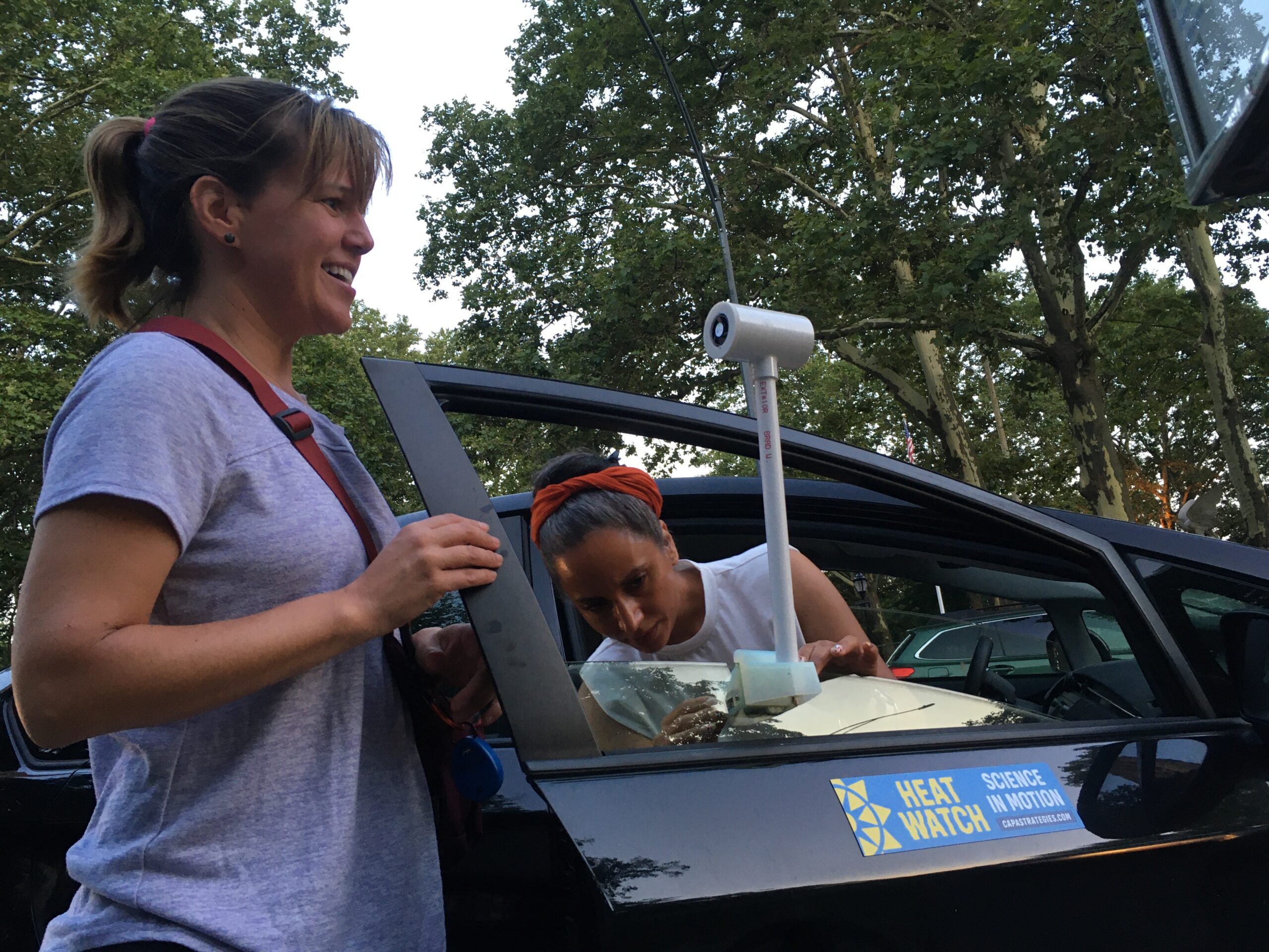
NEW YORK, N.Y.—A few weeks after a deadly June heat wave baked much of the United States, Francisco Casarrubias and another volunteer drove a 10-mile loop around the South Bronx with what looked like a small plastic periscope attached to the car’s passenger window. The sensor, which recorded the air temperature and humidity every second, was one of hundreds deployed around the country in a campaign to map the hottest neighborhoods in more than 20 cities, including New York.
Most people who live in cities know intuitively that areas with more concrete and asphalt are hotter than those with more parks, trees and water. Neighborhoods that were redlined in the 1930s—excluded from real estate investment, often because the residents were people of color or immigrants—tend to be hotter even now than others. This includes much of the South Bronx, which today is a densely populated and mostly low-income Black and Latino area
Community organizers hope to use the data collected this summer by volunteers like Casarrubias to make the case for investing in green space for the South Bronx. They want to usher in a new kind of development that improves residents’ health and quality of life, according to Melissa Barber, a physician and co-founder of the organization South Bronx Unite.
Over the years, the South Bronx and other redlined areas have received less funding for cooling parks and green spaces. At the same time, heavy industry and the diesel truck traffic it brings with it have concentrated in the same neighborhoods, which probably also raises the local temperature. Barber hopes the mapping project will help document this connection.
New York does have a heat map based on satellite data, which paints a picture of the city’s unequal heat distribution in broad strokes. This summer’s campaign, run nationally by CAPA Strategies and funded by the National Oceanic and Atmospheric Administration, will provide a much more granular, block-by-block heat map of Northern Manhattan and the South Bronx, according to Liv Yoon, a postdoctoral researcher at Columbia University who’s leading the mapping effort in New York.
“We wanted to target areas that actually mattered to people,” Yoon said, explaining that the researchers planned the volunteers’ routes together with South Bronx Unite and other community-based organizations, making sure to include busy bus stops, grocery stores, libraries and other corridors of activity.
Heat Becomes a Health Risk
Recent heat waves stoked by climate change have shown that rising temperatures are not just a matter of discomfort. In addition to causing conditions like dehydration and heat stroke, extreme heat can exacerbate health problems like asthma—a condition that people in the Bronx and Northern Manhattan suffer from disproportionately. For example, Mott Haven and Port Morris, the neighborhoods where South Bronx Unite works, are surrounded by highways, power plants, waste transfer facilities and warehouses. Traffic from the highways and from the trucks associated with the facilities has brought worse air pollution to the neighborhood than to the rest of New York, which experts say contributes to high rates of asthma.
“Everybody knows we’re called the asthma alley,” Barber said. “And there’s a reason for that, because of the levels of pollution.”

Experts and community members are urging local governments to help city neighborhoods that not only have higher temperatures, but also more people vulnerable to the health risks of extreme heat.
WE ACT for Environmental Justice, another New York City organization, recently released a report on heat vulnerability across Northern Manhattan. Researchers working with the group surveyed approximately 500 residents of Harlem, Washington Heights and Inwood—neighborhoods with sizable low-income and Black or Latino populations—about their experiences with extreme heat. WE ACT wanted to find out what residents did to protect themselves from summer heat waves, said Sonal Jessel, the organization’s director of policy.
While most of the people surveyed viewed heat waves as a serious risk, many lacked access to effective coping strategies. About 37 percent said they couldn’t afford or faced other barriers to using air conditioners at home, and only 17 percent said they used the city’s public cooling centers. The report identified most of Inwood as being particularly vulnerable, with higher temperatures and many residents who have preexisting health conditions or lack resources to cope with heat.
The city government is aware that some New Yorkers are more likely than others to get sick or die from heat exposure. One sector where officials are focusing their efforts is public housing run by the New York City Housing Authority. As with many older apartment buildings in New York, heat builds up in NYCHA buildings, said Siobhan Watson, a program manager for the agency’s recovery and resilience department.
It’s currently up to residents to purchase a window air conditioner if they want one. Although most NYCHA residents don’t have to pay an electricity bill, purchasing an air conditioner in the first place can be a big expense for someone living in public housing with a limited income. Approximately 74 percent of NYCHA households are registered as having an air conditioner, Watson said, although not all residents register their devices. This is compared to the city average of 89 percent.
“We know that heat risk is really in that margin” of people who lack air conditioning, she added.
Last year, NYCHA identified about 31,000 households without air conditioning that were especially vulnerable to heat because they had a resident over the age of 60, someone with a mobility impairment or someone who depended on life-sustaining medical equipment. The agency installed air conditioners in 16,000 of these households through a pilot program called “Get Cool.” The agency’s ultimate goal is to replace the heating systems in its apartment complexes with air source heat pumps that can also cool the buildings centrally, Watson said, and it is seeking federal funding to expand its cooling efforts.
Investing in Disadvantaged Neighborhoods
These household-level interventions certainly help, and can even save lives when targeted to the most vulnerable people. For example, Casarrubias, the volunteer who drove the heat sensor around the South Bronx, went and bought dehumidifiers during the last heat wave to keep his three young children and his wife, who still has some respiratory symptoms after contracting severe Covid-19 last year, more comfortable.
But Barber and others involved in this summer’s mapping project want the city to invest in making entire neighborhoods cooler and more resilient to the higher temperatures still to come with climate change.

Casarrubias has lived in the South Bronx since the 1990s, when he moved to New York City from Mexico. He’s felt the local climate changing, he said, with the past few summers reaching “high temperatures you never expected.” He’s also seen the borough change dramatically over the decades, as old apartment buildings and small businesses made way for shiny new developments. But parks and trees have not accompanied the new buildings. And even though the Bronx sits on a peninsula, the borough’s residents have very little public access to the waterfront.
“We can actually use this data to push for more green space, to push for that waterfront development,” said Barber. She hopes access to the water will help buffer residents from the heat they experience day in and day out during the summer. Barber also wants to use the data to push the city to open emergency cooling centers where they’re most needed, to add central air conditioning to apartment buildings and to update building codes to account for the dangers of heat exposure.
Keep Environmental Journalism Alive
ICN provides award-winning, localized climate coverage free of charge and advertising. We rely on donations from readers like you to keep going.
You will be redirected to ICN’s donation partner.
This heat mapping project is the culmination of years of work, she added. She and four other community members founded South Bronx Unite in 2012 to try and prevent a new Fresh Direct grocery distribution center—the latest truck-heavy industrial facility to set its sights on the South Bronx—from coming to the neighborhood.
Official environmental impact assessments by developers and companies like Fresh Direct do sometimes include sections on potential heat island effects, said Thomas Angotti, a professor of urban policy and planning at Hunter College who is not involved in the heat mapping project. But environmental impact assessments tend to be narrowly focused, he said. They don’t closely examine the heat’s effect on people nearby, or the potential inequalities of any resulting harm.
This kind of data is particularly relevant in Northern Manhattan and the South Bronx because these neighborhoods are “hotspots for new development,” Angotti said. “That’s where land values have been shooting up,” and where new development needs to be guided by sound information on the environment, health and equity.
As part of their campaign against Fresh Direct, Barber and her colleagues took it upon themselves to measure and model truck traffic, air pollution and noise in the neighborhood before and after the warehouse ultimately opened in 2018. They compiled the information into what they called a People’s Environmental Impact Assessment, which was also published as a study in the International Journal of Environmental Research and Public Health in 2020. After the warehouse opened, nighttime truck traffic increased by 10 to 40 percent at two sites in the neighborhood. That was accompanied by a small, predicted increase in black carbon pollution in the air and a forecasted increase in noise of approximately 30 percent.
“Now what’s left is to actually add heat data to that,” Barber said.
Fresh Direct did not respond to requests for comment.
Environmental Data Aids City Planning
Other cities are using similar data to make real changes on their streets. The city of Seattle and King County in Washington completed the same sensor-based mapping process in 2020, and are using the results to design bus stops with more shade and shelter in the hottest neighborhoods, said Joey Williams, a manager at CAPA Strategies.
Vienna, Austria began installing temperature, humidity and pollution sensors on its traffic lights in 2018. The sensors all feed into a central data processor run by the Austrian Center for Meteorology and Geodynamics (ZAMG), which identifies dangerous hot spots and also helps the city manage traffic to reduce air pollution. In Vienna too, densely populated and lower income neighborhoods are both hotter and more vulnerable to heat.
The city is already using the sensor data to create cooling zones with more vegetation and water in some of the hottest areas. The measurements also show the importance of air flow from greener areas outside the city to the urban core, said ZAMG urban climate modeler Maja Žuvela-Aloise. New development should be planned so it doesn’t block the cooling breezes, which would intensify the urban heat buildup, she said.
Whether they’re stationary as in Vienna or taken on drives, as in New York and Seattle, these temperature sensors give hyper-local data that can help city planners understand how specific pieces of infrastructure—like a road or a small park—affect the surrounding air temperature.
“There’s really limited understanding of the actual value of green infrastructure in terms of cooling benefits,” said Christian Braneon, a remote sensing specialist at NASA and a visiting professor of environmental science at Barnard College, who is advising the heat mapping project in New York.

Even when this information exists, sometimes it doesn’t get to city planners, according to Angotti.
“We’ve got tons of data silos all over the city,” he said, adding that the data from this mapping project should inform all of the city agencies that relate to public health—not just the Department of Health itself, but also the Department of Parks and Recreation, the Department of City Planning and the Mayor’s Office of Climate Resiliency.
Braneon is co-chair of the New York City Panel on Climate Change, a group that provides local policymakers with scientific information and advises the Mayor’s Office of Climate Resiliency. He hopes to include the results of the South Bronx heat mapping project in the panel’s next assessment for the city, which will also provide updated projections on how frequent and intense heat waves will get in the future.
After this summer, the urgency of dealing with heat exposure in cities around the world is clear.
“We know extreme heat is here. We know there’s a lot more heat waves,” said WE ACT for Environmental Justice’s Jessel. “How are we not ready for this already?”
Bob Berwyn contributed reporting for this story

Reporter, New York City
Delger Erdenesanaa is a fellow at Inside Climate News focused on environmental justice. She’s based in New York City and is a graduate student at New York University’s Science, Health & Environmental Reporting Program. Before becoming a journalist, Delger worked in international environmental policy and volunteered as an AmeriCorps VISTA in Utah. She studied Earth and oceanographic science at Bowdoin College.


