
Satellite pics show the demise of eerie ‘Earthquake Mountain’ in the Arabian sea
Nothing lasts forever. While we may think of the ground beneath our feet as part of an enduring landscape, the short-lived existence of a temporary island off the coast of Pakistan tells a much different story.
Zalzala Koh, aka ‘Earthquake Mountain’, was birthed in 2013 during a powerful 7.7 magnitude earthquake that killed over 800 people and razed as many as 21,000 homes to the ground. But this tragic event did more than simply destroy things.
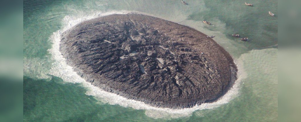
Once the tremors subsided, Pakistan discerned a new island that had arisen out of the tumult: an outcrop of mud and rock jutting from the bay waters of the city of Gwadar, produced by a mud volcano during the quake.
 Zalzala Koh on 26 September 2013. (Pakistan National Institute of Oceanography)
Unlike igneous volcanoes, which spew lava resulting from magmatic activity, mud volcanoes are formed when a slurry of gassy mud seeps upward through faults and fissures in the ground.
Small-sized mud volcanoes occur across much of the planet, often standing just a metre or two tall, but the variety along the Pakistan coastline tend to be giant, due to the ongoing collision of the Arabian and Eurasian tectonic plates.
As the Arabian plate gradually sinks under the Eurasian plate – a phenomenon known as subduction – soft clay sediments at the edge of the Eurasian plate start to build up, causing water and gas trapped in the rock to pressurise.
“The fluid pressures become so great that clay-rich sediments buried deep underground behave almost like a liquid,” geologist Mark Tingay from the University of Adelaide told NASA Earth Observatory.
“A mud volcano forms when the fluid pressures become large enough to fracture the overlying rocks that are sealing these intense pressures, allowing the muds and gases to erupt to the surface.”
When that scenario played out on 24 September 2013, Zalzala Koh (literally ‘Earthquake Mountain’ in Urdu, one of the national languages of Pakistan) emerged in Arabian Sea’s Gwadar Bay, initially reported to rise almost 20 metres above sea level, running over 150 metres long and more than 180 metres wide.
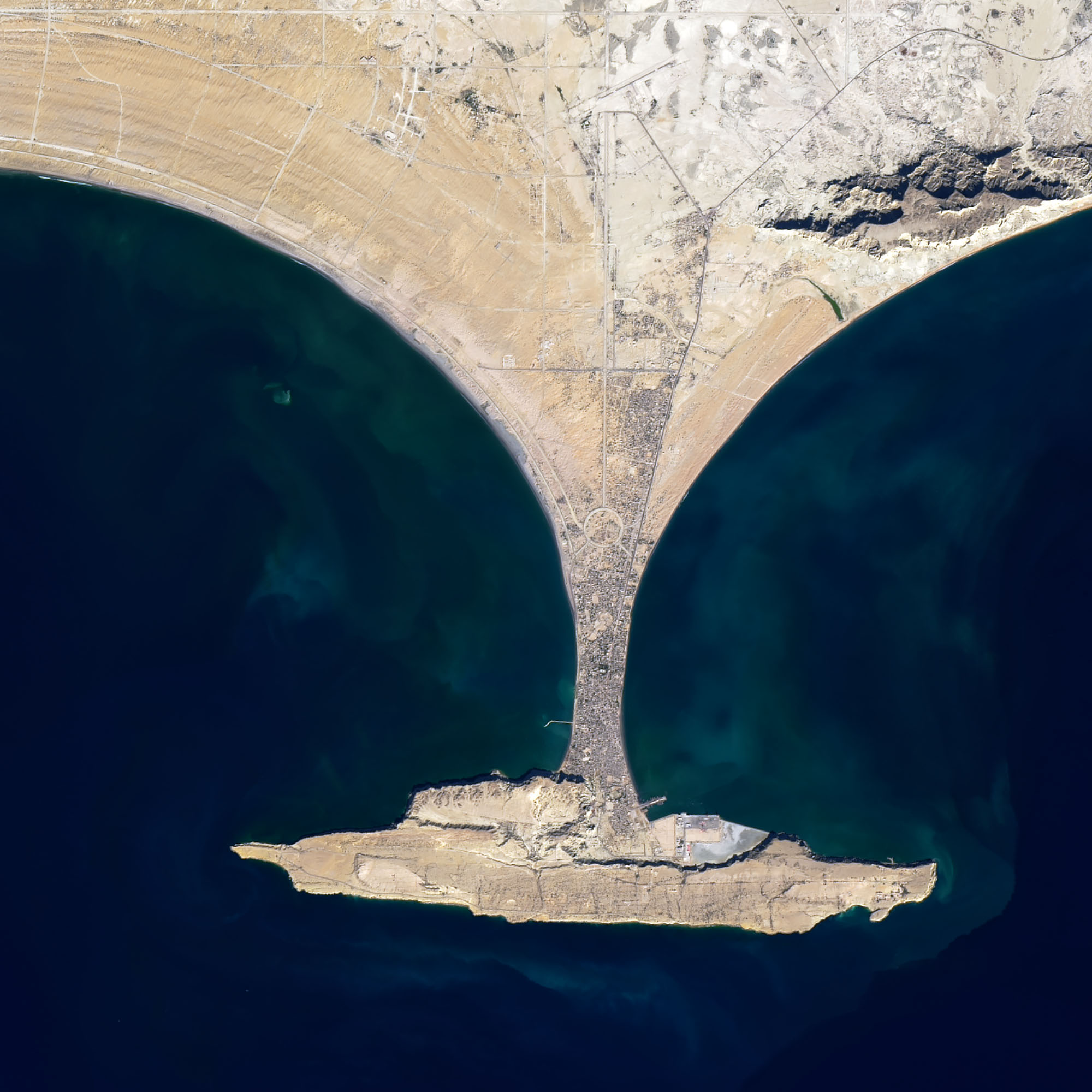
 Zalzala Koh on 26 September 2013. (NASA/Earth Observing-1 Satellite)
By island standards, Zalzala Koh might have been considered small, but compared to most mud volcanoes on the planet’s surface, this thing was huge – a discrete land mass clearly visible via satellite.
That unique top-down perspective is also what gives us the best record of Earthquake Mountain’s inevitable demise.
Due to their mushy composition of mud and rock, formations like Zalzala Koh are prone to rapid erosion – a process that was already evident less than two months after the mud island first appeared.
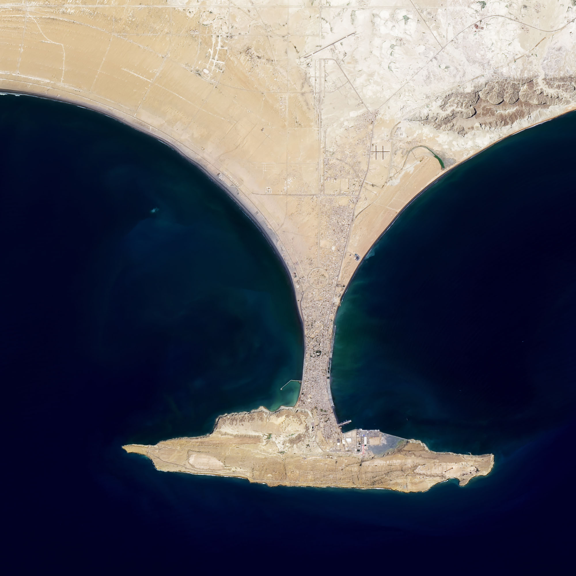
By late 2016, locals reported the mud formation had disappeared from view at high tide, although a contemporaneous overhead shot from November 2016 (also seen below) from NASA’s Landsat 8 satellite clearly reveals the footprint of the island lurking just below the surface of the water.
 Zalzala Koh timeline 2013 to 2019. (NASA/Earth Observing-1 Satellite)
Fast-forward to a more recent image, though – taken on April 27 of this year (and seen above) – and it’s clear Zalzala Koh has now been all but swallowed by the sea, showing only a faint hint of the island’s hidden existence under the waves.
It’s not necessarily the end for this muddy mass just yet though. Other islands produced by mud volcanoes in the region have been known to reappear after vanishing, like Malan Island to the east, which has emerged at least twice from the depths, and maybe even three times.
Whether Zalzala Koh can pull off the same trick is unknown, but if ‘Earthquake Mountain’ does rise from the depths again, we can only hope the accompanying circumstances next time aren’t so devastating.

